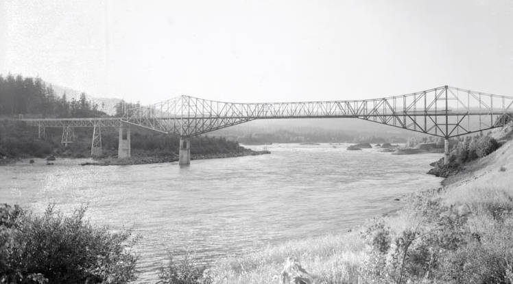
In the heart of the Columbia River Gorge, a 1,858-foot-long steel-truss bridge spans the Columbia River at Cascade Locks, about forty miles east of Portland. The Bridge of the Gods, first built in 1926, derives its name from a much larger Bridge of the Gods that covered a part of the Columbia River in about 1450 AD. The earlier “bridge” was a blockage caused by the Bonneville Landslide, which headed on the southern escarpment of the 3,417-foot-high Table Mountain on the Washington side of the river and cascaded downward, filling the Columbia River valley with more than five square miles of debris up to 400 feet thick.
The Bonneville Landslide almost certainly gave rise to the Klickitat legend of the Bridge of the Gods. Oral tradition about the bridge tells how people “could cross the river without getting their feet wet.” Reportedly, “the river was dammed up at this place, which caused the waters to rise to a great height far above and that after cutting a passage through the impeding mass down to its present bed, these rapids first made their appearance.”
The rapids became known as Cascade Rapid, sometimes called the Cascades of the Columbia, a set of rocky rapids descending more than 22 feet over about 600 yards and then another 30 feet over the next 8 miles. The rapids are the remnant debris of the landslide dam. After blockage by the Bonneville Landslide, the Columbia River formed a great lake behind the debris dam, perhaps 300 feet deep and extending as far as Wallula Gap, about 170 miles upstream.
Sometime after overtopping, the river cut through around the southern edge of the landslide mass. The downcutting was not yet complete, however, and large rocky debris too big to be carried away by the river remained, creating the set of foaming rapids, first mapped by Meriwether Lewis and William Clark as “The Great Shoot.” Cascade Rapid was drowned in 1938 by Bonneville Dam.
The landslide and resulting rapids created a choke point in the Columbia River Gorge that had immediate and persistent consequences on the human use of the river. The narrowing of the river created prime fishing spots that supported Cascades and Chinookan people who settled in the vicinity of the landslide soon after the river found its course around and through the blockage. Cascade Rapid was a significant navigation hurdle, which fostered a local portage economy and occasionally violent conflicts because of its strategic location.
The 1896 completion of Cascade Locks and Canal finally permitted uninterrupted navigation between The Dalles and the coast. The constricted river valley at the downstream end of the landslide toe provided an obvious location for 20th century construction of Bonneville Dam, and, at the upstream end of the former blockage, for the present steel-truss version of the Bridge of the Gods.
-
![This man-made bridge spans the part of the Columbia River once blocked by a giant landslide, which formed a natural bridge across the water.]()
Bridge of the Gods.
This man-made bridge spans the part of the Columbia River once blocked by a giant landslide, which formed a natural bridge across the water. ORU_PH037_0481 University of Oregon Archives
-
![]()
Cascade landslide complex map, showing Bonneville landslide boundaries.
Courtesy U.S. Geological Survey

Related Entries
-
![Bonneville Dam]()
Bonneville Dam
The U.S. Army Corps of Engineers built and operated Bonneville Lock and…
-
![Cascade Locks]()
Cascade Locks
A massive ground movement known as the Bonneville Landslide, which occu…
-
![Columbia River]()
Columbia River
The River For more than ten millennia, the Columbia River has been the…
-
![Western Oregon Klikatats (Klickitats)]()
Western Oregon Klikatats (Klickitats)
Between the 1810s and 1850s, a sizable segment of the Klikatat Tribe of…


Related Historical Records
Map This on the Oregon History WayFinder
The Oregon History Wayfinder is an interactive map that identifies significant places, people, and events in Oregon history.
Further Reading
Lawrence, D.B., and E.G. Lawrence. "Bridge of the gods legend, its origin, history and dating." Mazama 40.13 (1958): 33-41.
O’Connor, J.E. "The evolving landscape of the Columbia River Gorge—Lewis and Clark and cataclysms on the Columbia." Oregon Historical Quarterly 105.3 (2004): 390-421.
Palmer, L. "Large landslides of the Columbia River Gorge, Oregon and Washington." Engineering Geology 3 (1977): 69-84.