Dee refers to a lumber-mill town located on the Middle Fork of the Hood River, occupied from 1906 to 1959, and to the adjacent orchard district sometimes known as Dee Flat. The town site lies along Oregon Highway 281 ten miles southwest of the town of Hood River. Dee Flat is a triangle of roughly two square miles located west of the convergence of the West Fork of the Hood River with the Middle Fork. It consists of gently rolling land that sits two hundred feet above the rivers, with steep slopes on both sides.
Dee was the creation of the Oregon Lumber Company, a firm established by Salt Lake City businessman David Eccles, who simultaneously built the Mount Hood Railroad to serve the county’s growing timber and orchard industries. It took its name from Thomas Dee, a stockholder and company officer.
The company acquired Dee Flat from members of the extended Winans family and logged it from north to south. The company continued logging operations on Middle Mountain to the east of the mill and farther up the valley of the West Fork with the help of a logging railroad on the south side of the valley. A hardboard facility was added in 1951.
Dee was a company town for mill workers and their families. Although the first workers lived in boxcars, the company soon built a two-story hotel, a store, and small houses, all located on the east side of the Middle Fork (roughly below where a water tower now stands along Highway 281). The town was most substantial in the 1910s and 1920s, with a peak population of perhaps 250.
The increased use of automobiles and road improvements allowed workers a greater choice of where to live and reduced the attraction of living under smokestacks. Hines Lumber Company purchased the mill and town property in 1958 and dismantled the remaining housing in 1959-1960, at which time the Dee post office also closed.
Wood products operations continued under several operators until Champion Paper closed the facility in 1984. New Zealand investors reopened it as Dee Forest Products in 1986. In 1996, a spectacular fire destroyed most of the buildings and ended operations.
Many of the original residents of Dee Flat were mill workers who took up cutover acreage and cleared stumps for apple and pear orchards beginning in about 1910. A ditch drew irrigation water from the West Fork, four miles upstream from the flat. Many early agriculturalists were Japanese immigrants, and several families still operate orchards a century later. Early institutions included a Japanese community center, which served several dozen families, and a school, built in 1926 on the edge of the plateau overlooking the mill—a compromise location to serve both mill town and farm families.
Tens of thousands of recreationists view Dee Flat as they pass through on the road to Lost Lake, which was first roughed out in 1910. It remains an active and prosperous agricultural district, with a population of 361 at the 2000 census. When the Dee Volunteer Fire District merged with the Parkdale Rural Fire District in 2006 (with a vote of 109 to 17), however, the Dee Irrigation District remained as the community’s last formal institution.
-
![]()
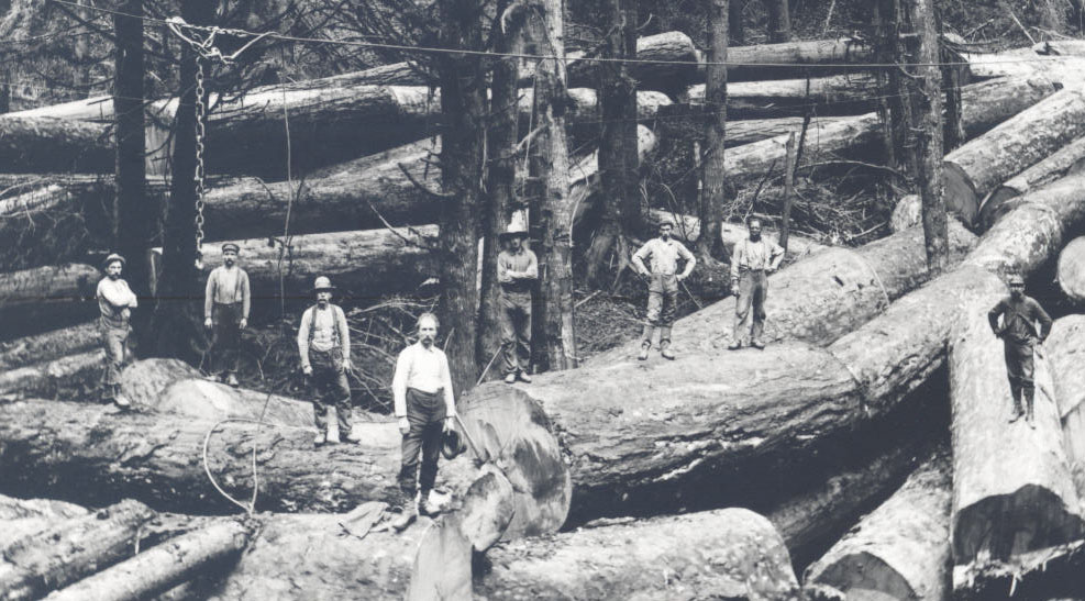
Oregon Lumber Co., Dee, July 25, 1932.
Courtesy University of Oregon Libraries -
![]()
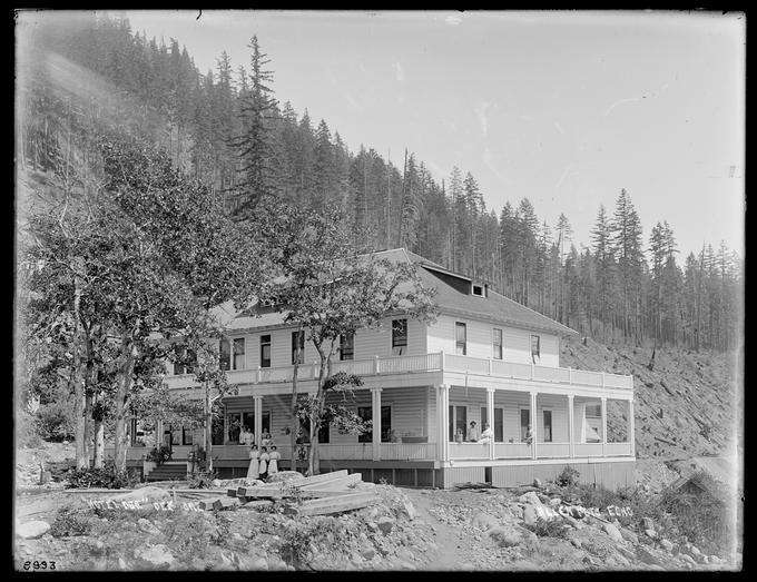
Hotel Dee, c.1900.
Courtesy University of Oregon Libraries, Thomas Leander Moorhouse

Related Entries
-
![Company Towns]()
Company Towns
While there have been scores of industrial settlements and communities …
-
![Hines and the Edward Hines Lumber Company]()
Hines and the Edward Hines Lumber Company
In the mid-1920s, large sawmill owners in the United States found a new…
-
![Hood River (city)]()
Hood River (city)
Situated in the Columbia River Gorge about sixty miles east of Portland…
-
![Oregon-American Lumber Company]()
Oregon-American Lumber Company
The Oregon-American Lumber Company (1917-1934) and its successors—the O…
-
![Timber Industry]()
Timber Industry
Since the 1880s, long before the mythical Paul Bunyan roamed the Northw…


Map This on the Oregon History WayFinder
The Oregon History Wayfinder is an interactive map that identifies significant places, people, and events in Oregon history.
Further Reading
Carlson, Linda. Company Towns of the Pacific Northwest. Seattle: University of Washington Press, 2003.
Friedman, Ralph. In Search of Western Oregon (2nd ed). Caldwell, Id.: The Caxton Printers, Ltd., 1990.