Winding for 382 miles along the Oregon Coast, the Oregon Coast Trail is the most extensive and popular recreational trail built and maintained by the State of Oregon. The Coast Trail consists in part of formally designated and maintained trails over majestic headlands, often cutting a narrow swath through otherwise impenetrable forests of shrubby salal, towering Sitka spruce, and a tangle of native ferns. These segments are linked by designated, passable routes down sandy beaches, through coastal towns, and occasionally along highway shoulders. The trail was born out of initiatives in the early twentieth century to protect Oregon’s beaches as a public asset. From its inception, it was designed, constructed, and maintained by the Oregon Parks and Recreation Department (OPRD), the agency responsible for managing over half the trail route where it follows beaches or crosses coastal state parks (roughly two hundred miles).
The Oregon Coast Trail had its beginnings on February 11, 1913, when Governor Oswald West signed into law legislation designating the ocean shoreline as a public highway and reserving it for public use. That early legislation, however, secured only the wet sand portion of the beach; the upper dry sands often were owned privately and, therefore, were available for development. Still, the statute provided public access along much of the coast and enshrined in Oregon law the concept of the oceanfront as a public transportation corridor. The Beach Bill of 1967 secured the protection of the upper beach and created a permanent public easement from the foredune to the sea.
A de facto coast trail has always been fundamental to the human geography of the Oregon Coast. Native trails traditionally followed the beaches, linked by trails over headlands and canoe portages across major waterways. Native communities often monitored, maintained, and sometimes marked those trails in myriad ways. These trails kept villages linked together, even when ocean conditions were too rough for canoes. Nineteenth-century fur traders and pioneers often followed these Native American routes or modified them slightly to reduce steepness or accommodate horses and wagons. Cultural geographer Samuel N. Dicken, a professor of geography at the University of Oregon, devoted decades to documenting the historical geography of the Oregon Coast, including the evolution of the historic trails. In a 1959 document, he first laid out the concept for a public Oregon Coast Trail that would largely follow historic trail routes.
The concept of a trail proved to have broad support from local governments, coastal residents, economic boosters, hiker clubs and statewide conservation groups. Despite growing public interest, Oregon State Parks did not begin developing the Coast Trail until passage of the Oregon Recreation Trails System Act in 1971. Dicken then articulated his vision, including an overview of the Trail’s historical precedents and its specific proposed dimensions, in his Oregon Historical Society Press book, Pioneer Trails on the Oregon Coast (1971), and a planning and assessment report for the State of Oregon, Plan for a Hiking Trail on the Oregon Coast (1973).
The first segment of the trail was completed in 1975, from the Columbia River to Tillamook Bay, linked by beaches, headland trails through state parks such as Ecola and Oswald West, and segments of Highway 101. That summer, together with Oregon Governor Robert Straub, Dicken cut the ribbon at a ceremony in Oswald West State Park that dedicated the first segment of the Trail.
Though the Oregon Coast Trail was considered ready for hiking in 1988, there remained many “critical gaps,” that is, stretches where hikers have to use a transportation corridor not designed for walkers. Natural features cause most of the gaps, such as a wide bay, a headland, rocky cliffs, or a river without a crossing. In a few cases, unnavigable private lands also create gaps. Hikers are sometimes forced to take substantial detours, and several gaps compel them to trek alongside Highway 101, go through a tunnel designed only for cars, or ask boaters for an impromptu ferry ride.
A 2005 assessment by the National Coast Trails Association led to an updated Oregon Coast Trail Plan that addressed strategies to tackle the gaps and identified partners that could collaborate with the Oregon Parks and Recreation Department to provide local support for the OCT. Vigorous stakeholder meetings along the coast in 2009 and 2010 culminated in a report in 2011, “Oregon Coast Trail: Connection Strategy,” which provided detailed alternatives for thirty-one critical gaps, totaling some fifty miles in length.
The legislature in 2017 passed House Bill 3149 to encourage completion of the Oregon Coast Trail. The act, co-sponsored by many coastal legislators, required OPRD—in collaboration with the Department of Transportation, local governments, and nonprofit organizations—to develop an Action Plan by 2020 that identifies preferred routes, maintenance and operation needs, and possible funding sources. The act also requires OPRD to submit annual reports showing progress toward full completion of a coastwide trail without critical gaps.
Coastal visitors frequently use the more spectacular portions of the trail for a day hike. Despite increasing popularity for throughhikers—that is, hikers who walk the trail from start to finish—the Oregon Coast Trail is not managed with a focus on long-distance backpackers, who require regularly spaced campsites and clear signage. The trail goes through or near many coastal towns but does not offer specific accommodations. OPRD has added mileage markers at key junctions and access points. Portions of the trail traversing sensitive habitats, such as the sandy breeding grounds of western snowy plover, seasonally require pedestrians to only walk on the wet sands. There are occasional geological hazards and tide-dependent passages, and mud is a perennial challenge on headland trails—especially in winter and on heavily visited segments.
Despite the remaining gaps and other minor inconveniences, the Oregon Coast Trail is a popular recreational trail that gives hikers unparalleled views of emerald headlands and plunging cliffs, long unspoiled beaches and majestic dunes, and coastal towns where walkers can rest, eat, and sleep.
-
![]()
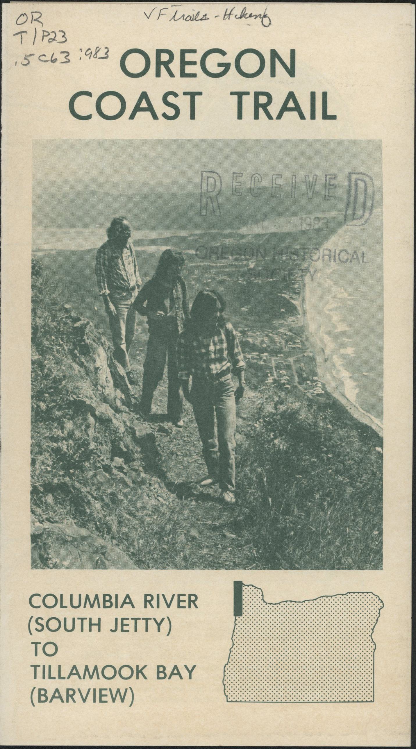
Oregon Coast Trail pamphlet, c.1983.
Courtesy Oregon Hist. Soc. Research Lib., ORTIP23.5c63, vertical file Trails-hiking
-
![]()
Map of the Oregon Coast Trail, c.1983.
Courtesy Oregon Hist. Soc. Research Lib., ORTIP23.5c63, vertical file Trails-hiking

Documents
Related Entries
-
![Oregon Beach Bill]()
Oregon Beach Bill
Oregonians struggling to maintain public access to Pacific Ocean beache…
-
![Oswald D. West (1873-1960)]()
Oswald D. West (1873-1960)
Oswald D. West served as Oregon's fourteenth governor, between 1911 and…
-
![Robert Straub (1920-2002)]()
Robert Straub (1920-2002)
Robert W. Straub, Oregon’s thirty-first governor, was a plainspoken pol…
-
![Thomas William Lawson McCall (1913-1983)]()
Thomas William Lawson McCall (1913-1983)
Tom McCall, more than any leader of his era, shaped the identity of mod…


Related Historical Records
Map This on the Oregon History WayFinder
The Oregon History Wayfinder is an interactive map that identifies significant places, people, and events in Oregon history.
Further Reading
Dicken, Samuel N. Pioneer Trails of the Oregon Coast. Portland: Oregon Historical Society Press, 1971.
Dicken, Samuel N. Plan for a Hiking Trail on the Oregon Coast. Unpublished report in possession of the Oregon Parks and Recreation Department, Salem, 1973.
Henderson, Bonnie. Day Hiking the Oregon Coast, 2nd Edition. Portland, Ore. The Mountaineers Books, 2015.
Oregon Parks and Recreation Department. Oregon Coast Trail Action Plan Update. 2018. Salem, Ore.: Oregon Parks and Recreation Department.
Oregon Parks and Recreation Department. Oregon Coast Trail: Connection Strategy. January 2011. Salem, Ore.: Oregon Parks and Recreation Department.
Price, Ed. "Geography at the University of Oregon." Yearbook of the Association of Pacific Coast Geographers 52 (1990): 140-52.
Soper, Connie. Exploring the Oregon Coast Trail: 40 Consecutive Hikes from the Columbia River to the California Border. Portland, Ore. Dragonfly Press, 2015.
"Oregon Coast Trail Maps." Oregon Parks and Recreation Dept. https://www.oregon.gov/oprd/parks/pages/oct_main.aspx