The cartographic history of Oregon as a place in the Pacific Northwest began long before European visitation to the region. Mapmakers initially conceptualized the presence of a separate North American continent in 1507, some 234 years before the first recorded sighting of a landmark on the Pacific Northwest coast in 1741 and 315 years before the word "Oregon" identified a region on a map in 1822.
Mapmakers always drew on a variety of sources to represent territory. For the Pacific Northwest, these included actual and apocryphal accounts of explorations, as well as long-established geographical concepts of a navigable water passage north of the continent (the Northwest Passage) or through it (the River of the West). Thus, ideas of what a place looked like were shaped by ideas about how to get there.
Voyages of Russians, Spanish, English, French, and Americans during the eighteenth century resulted in a reasonably accurate cartographic rendering of the North Pacific coast. During the first half of the nineteenth century, sources of information for mapmakers were explorers, statesmen, politicians, and entrepreneurs; and maps reflected ambitions, ideologies, and attempts to claim, name, and control the region.
This essay draws from extant cartographic history written in Western European mapmaking traditions. Native American contributions are referred to, but the culturally rich, dissimilar traditions of Native peoples that incorporated understanding of geography into oral traditions are not discussed.
Mapping Ideas of Place and How to Get There, 1507–1700
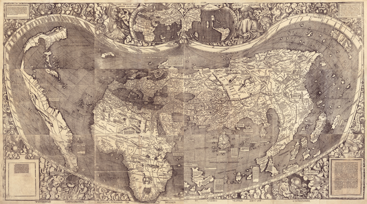
The earliest printed maps of the world showed newly “discovered” lands in proximity to Asia. The world map of Martin Waldseemüller, published in Strasbourg in 1507, was best known as the first map to feature the toponym America, but it was also the first to suggest that these new lands were part of a separate continent that lay between Europe and Asia. Waldseemüller engraved Terra Ultra Incognita in the northwest region of this conjectural continent. “Almost any successive mapmaker of note for the next twenty-five years,” cartobibliographer Rodney Shirley wrote, “relied almost exclusively on Waldseemüller’s great work.”
In 1561 in Venice, Giacomo Gastaldi, one of the most prolific and influential mapmakers of the period, published a pamphlet and map that depicted a narrow waterway between northeastern Asia and northwestern America. He called it the Strait of Anián, a name drawn from travel accounts of Marco Polo. Although this part of the world was not visited by Europeans until the mid-to-late-eighteenth century, Gastaldi’s map promoted the geographical concept of a navigable connection between a Northwest Passage and the South Sea (Pacific Ocean). This representation of the North Pacific and the Pacific Northwest was adopted by many commercial mapmakers, including Abraham Ortelius in Antwerp. Ortelius’s map, America Sive Novi Orbis Nova Descriptio, appeared in over forty editions of his atlas, Theatrum Orbis Terrarum, from 1570 to 1612.
In 1582, Michael Lok, in London, produced Illustri Viro Domino Philippo Sidnaeo Michael Lok, a map that depicted a prominent Northwest Passage in the vicinity of 45°–48°. The map was influential in stimulating subsequent English voyages in search of a passage across the continent to the vicinity of the Pacific Northwest. In 1593, Cornelis de Jode, in Antwerp, printed the first large-scale map to conceptualize the region of the Pacific Northwest. He titled his map Quivirae Regnv, a name that originated from early Spanish explorations in the area.
Three seventeenth-century maps were evidence that mapmakers from several countries were still occupied with how to conceptualize the Pacific Northwest, even in the absence of explorations along the coast above ~43º. Although Spanish printed maps of the Americas were rare, in 1601 Antonio de Herrera y Tordesillas in Madrid published the first parts of his Historia General, which included several maps such as Descripcion de las Indies Occidentales. On this map, the Northwest coast contained one placename and extended northeast from ~47º. Derivatives were republished several times.
In 1626, John Speed, in London, issued an atlas containing a map of “America,” the first in an atlas to depict California as an island. The map suggested that a distinct coastline extended south from ~60º between the mainland and an insular California. In Florence in 1648, Robert Dudley issued an atlas containing Carta particolare dello streto di lezo, arguably the earliest printed sea chart of the Pacific Northwest with a well-defined coast that extended from ~38º to 50º. Dudley’s large-scale rendering, replete with placenames of coastal features above ~43º, was highly imaginative.
Transcontinental Water Routes and First Voyages, 1700–1753
During the eighteenth century, France was the center of commercial mapmaking in Europe. Membership in the Royal Academy of Sciences and close association with rulers of the state (Premier de Sa Majeste) enhanced the prestige of mapmakers such as Guillaume de L'Isle. On Carte D’Amerique, first published in Paris in 1722, de L'Isle left a blank space in the unexplored region of the Pacific Northwest above ~45º. But he supported the feasibility of a transcontinental water passageway to the region by introducing for the first time on a printed map the legend “Entrée decouverte par Martin Aguilar” on the coast at ~45º. In the interior, de L'Isle drew a lake at ~47º, with a short river segment extending west with the legend “Grande Riviere Coulant a L’Ouest” (River of the West). On many of the more than over twenty editions of Carte D’Amerique, de L'Isle incorporated new information in the cartography of the Pacific Northwest.
In 1752, Joseph Nicolas de L'Isle and his brother-in-law Philippe Buache published Carte des Nouvelles Decouvertes au Nord de la Mer du Sud, which had been presented to the Royal Academy of Sciences in 1750. This was one of the first published maps to record (although incompletely) the route of the 1741 voyage of Vitus Bering and Alexei Chirikof in the North Pacific to America. The map also contained apocryphal geographic information both on the presence of a large inland sea "Merou Baye de L’Ouest" (Sea of the West), with a coastal entrance at ~43º, and a transcontinental water route between Hudson Bay and the Pacific Ocean at ~63º. De L'Isle and Buache based this apocryphal information on published accounts of fabricated voyages of Juan de Fuca and Admiral Bartholomew de Fonte.
In response, the Russian Academy of Sciences instigated the publication of a pamphlet and map in Berlin in 1754 by Gerhard Fredrich Müller, a German who was secretary of the academy. On Nouvelle Carte Des Decouvertes Faites Par Des Vaisseaux Russines, Müller more accurately depicted the track of Bering and configured the Alaskan land mass differently. Derivatives of the maps of de L'Isle, Buache, and Müller were republished many times. Knowledge of a Russian presence on the North Pacific Coast prompted English and Spanish planning for voyages to the region.
Mapping Domain, 1755–1802
In the mid-eighteenth century, the most influential French geographer was Jacques Bellin. In 1766, on his Carte Reduite de L’Ocean Septentrional Compris Entre L’Asie et L’Amerique, Bellin retained most of Müller's rendition of the North Pacific Ocean and Pacific Northwest coastline, including elimination of the mythical Sea of the West. In the interior, Bellin showed prominent water, Route de L’Ouest, that extended from sources on the upper reaches of the Mississippi River and Lake Winnipeg west through mountainous lands of the Assiniboine and Serpent Indians.
Spain renewed exploration to the Pacific North Pacific Coast in 1774 and 1775, which resulted in formal acts of possession and the earliest recorded European sighting of the estuary of the Columbia River (named Entrada de Ezeta on subsequent Spanish maps) on August 17, 1775, by Bruno de Hezeta. Several extant manuscript maps documented this “discovery,” including Carta reducida de las costas y mares septentrionales, drawn by Hezeta in 1775. Although Spain’s policy of secrecy precluded publication of the maps until the end of the eighteenth century, news of Spanish discoveries leaked out. In 1775, in London, Thomas Jefferys published A Chart containing the coasts of California, New Albion and Russian Discoveries, a large map that contained legends that summarized geographic controversies along the North Pacific Coast and in the Pacific Northwest.
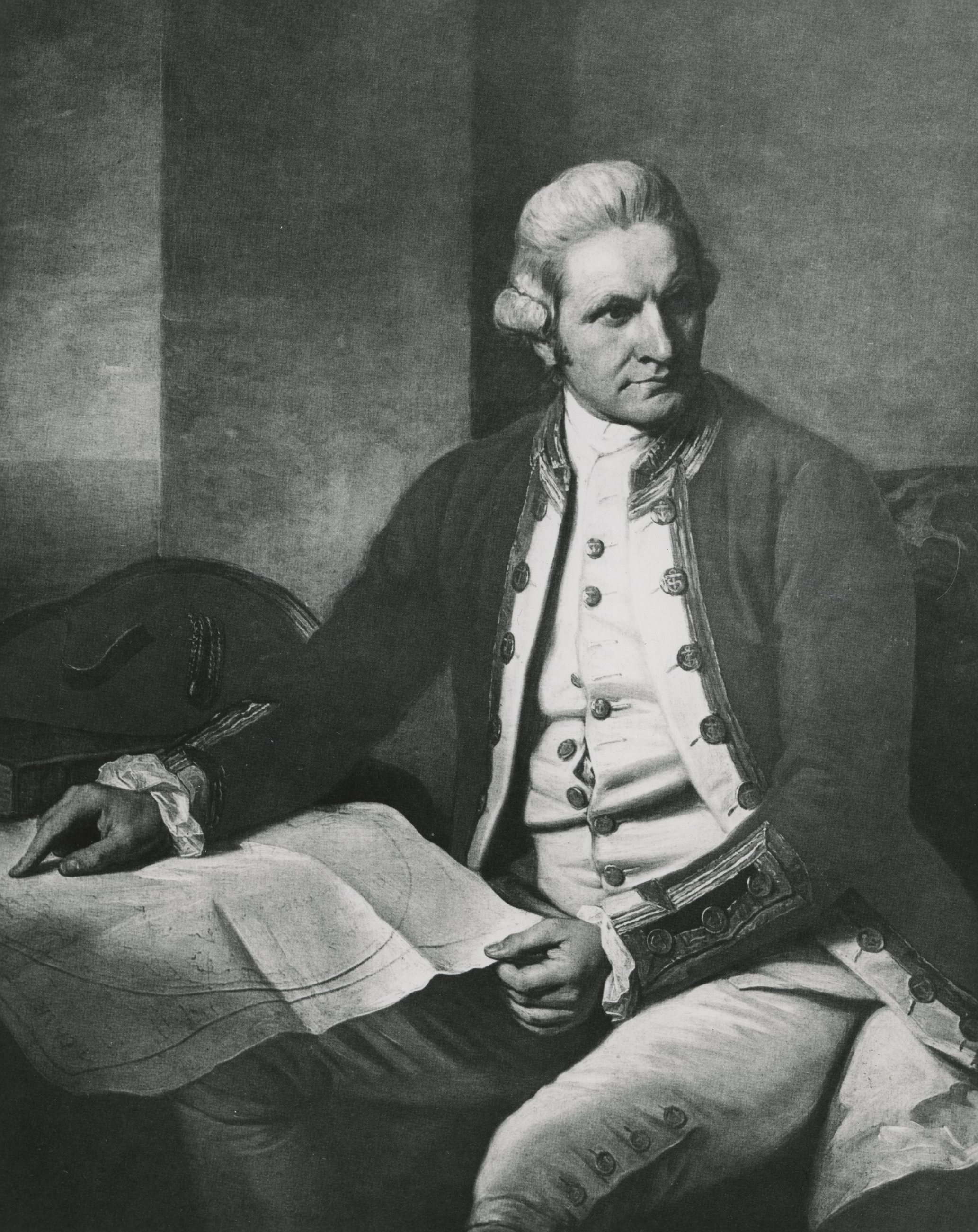
The official account of Captain James Cook’s third voyage, which took him to the Northwest Coast in 1778–1779, was published in 1784. The accompanying atlas included Chart of the NW Coast of America, drawn by Lieutenant Henry Roberts. The map showed the tracks of Cook’s reconnaissance from Cape Gregory, at ~42º north to ~70º. Several names given to coastal features by Cook are a cartographic legacy to that great navigator.
The extensive maritime surveys of Captain George Vancouver from 1792 to 1794 resulted in the most elegant and accurate cartography of the Northwest Coast, which had begun with the sighting of the American coastline by Bering and Chirikof. The account and atlas of Vancouver’s expedition, published in 1798, contained at least two maps that included sections of the Oregon Coast. A chart showing part of the coast of NW America, Plate 14, depicted the coast from ~30º to beyond 58º. Plate 5 showed details from ~45º to ~52º and contained a section of the Columbia River explored by Lieutenant William Broughton in 1792, the first published map to designate the river by the name given it by the American Robert Gray in May 1792. Placenames and topographical features from Vancouver’s charts, particularly the shape of the Columbia River from Cape Disappointment to Point Vancouver, were promptly incorporated into maps of North America by all of the principal commercial mapmakers in America and Europe.
Claiming and Naming, 1800–1825
Maps of the first quarter of the nineteenth century reflected both emerging knowledge of the internal topography of the Northwest and the geopolitical ambitions of Britain and the United States. The account of Alexander Mackenzie’s transcontinental march to the Pacific Ocean in 1792–1793 was accompanied by A Map of America between the Latitudes 40 and 70 and Longitudes 45 and 180 West that included information from the explorations of David Thompson.
Published in London in 1801, MacKenzie's narrative was widely distributed in Europe and the United States. The map mistakenly depicted the course of the Columbia River and foreshortened the extent of territory west of the Rocky Mountains. Nevertheless, it influenced President Thomas Jefferson during planning for westward exploration and was part of the traveling library of Meriwether Lewis and William Clark.
Aaron Arrowsmith’s A Map exhibiting all the new discoveries in the interior parts of North America, updated to 1802, incorporated the latest information from maritime exploration and Mackenzie’s report. More importantly, it suggested potentially navigable water routes between the great bend of the Missouri River and the Rocky Mountains and then beyond to the sea. Notably, Arrowsmith indirectly obtained information on the hydrography of the interior West from maps drawn by Natives familiar with the territory.
In 1801, Ac ko mok ki, a Blackfoot chief, supplied Hudson’s Bay Company operative Peter Fidler with geographical information on a large area of the upper Missouri River. Fidler drew a map from this information, and that transcription was sent to Arrowsmith. It is one of many examples of the use of geographical information supplied by Natives to British and American surveyors and mapmakers during this period.
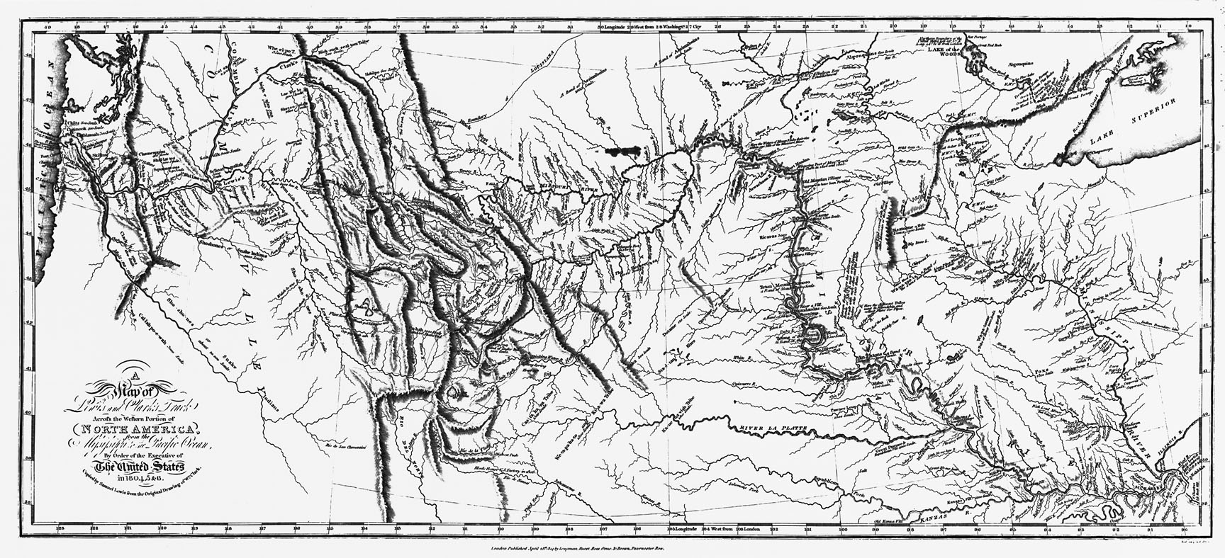
In 1806, Meriwether Lewis and William Clark obtained geographical information from Indian informants, especially on the complex hydrography of river systems west of the Rocky Mountains. Many of Clark’s transcriptions of this information survive, and he included this intelligence on his final composite map. Clark’s A Map of part of the continent of North America, completed in about 1810, was arguably the most influential map of this entire history. It incorporated more information than the reduced and less detailed A map of Lewis and Clark’s track across the western portion of North America, published in 1814. By 1815, the complex topography and hydrography of the Rocky Mountain region and the Pacific Northwest had been copied on maps published in London and Paris.
Over the next decade, international interest in dominion and boundaries in the region was reflected in the remarkable wall maps of Philadelphia-based mapmakers John Melish and Henry Tanner. Melish’s 1816 Map of the United States with the Contiguous British and Spanish Possessions was widely regarded as the first map to suggest a potential continental expansion of the United States. Subsequent editions of this map (35 x 57 inches in size) reflected early British and American attempts to negotiate a boundary in the Pacific Northwest extending from the Rocky Mountains to the Pacific Ocean at ~49º. An 1819 version of Melish’s map was the first to show the boundary of 42º between Spanish dominions in Alta California and those of the United States that later became the southern border of Oregon.
In 1822, Henry Tanner’s great Map of North America included for the first time the name "Oregon Terr." and also eliminated the 49º boundary from the Rocky Mountains to the Pacific Ocean. Tanner’s source for this name was a congressional bill introduced by Representative John Floyd of Virginia six months earlier that proposed extending US sovereignty over a new Oregon Territory. Through published congressional debates and cartographic literature, two concepts entered the public consciousness: the idea of applying the name "Oregon" to a place in the Pacific Northwest, and the territorial expansion of an American republic into the region.
In 1825, Tanner reissued his Map of North America and included a boundary that partitioned the Pacific Northwest between Britain and the United States at 54º40' reflecting recent (1824–1825) conventions and eliminating Russian influence south of that line. By the end of the 1820s, most American mapmakers depicted a large Oregon Territory bounded by latitudes 42º and 54º40’ and from the Pacific Ocean to the Rocky Mountains. This was the appearance of the part of the continent that became familiar to a generation of American map readers until the Oregon Treaty of 1846.
Mapping and Roots of Manifest Destiny, 1825–1848
At the beginning of the 1830s, thousands of Natives and a few hundred employees of the Hudson’s Bay Company lived in the area designated on maps as “Oregon Territory.” A few Americans in the East had publicly declared interest in settlement in the region. None was more tireless than Hall Kelley, whose Map of Oregon and sketch of a proposed city near the confluence of the Multnomah and Columbia Rivers were separately published in 1830. Although Kelley did not travel to Oregon until 1834, the maps reflected increasing popular interest in what was now widely mapped as Oregon Territory.
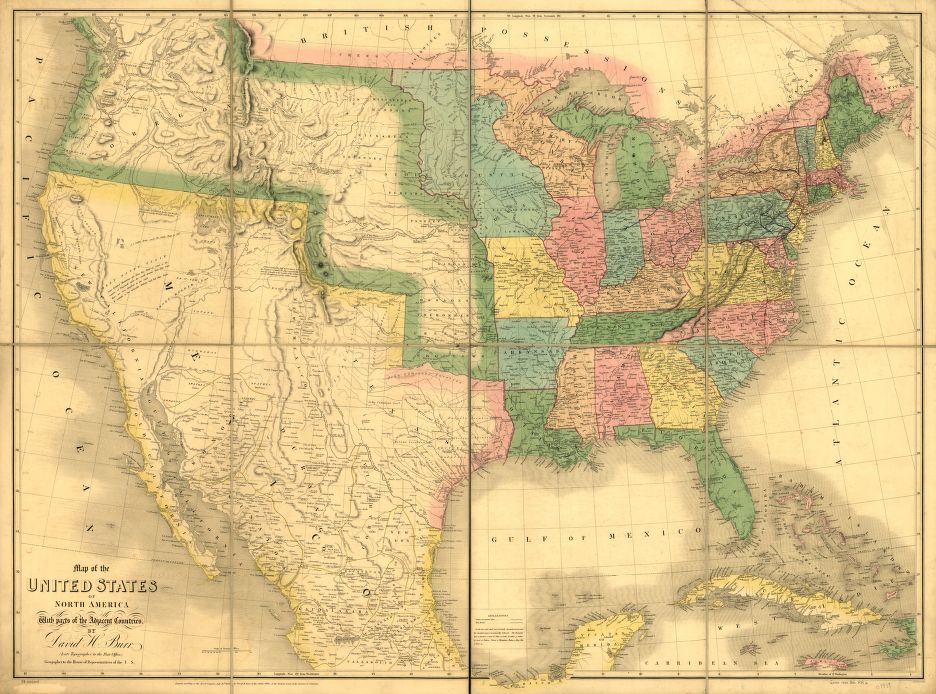
In 1833, David Burr—cartographer, surveyor, and topographer to the US Post Office Department—copyrighted his map of “Oregon Territory” that was published in his 1835 New Universal Atlas. It was, perhaps, the first American-authored large-scale map of the area. In 1836 and 1837, Washington Irving popularized the Astorians and the Oregon region (although not by name) with his Sketch of the Routes of Hunt and Stuart and Map of the Territory West of the Rocky Mountains, the latter drawn by Captain Benjamin Bonneville. In 1838, Samuel Parker drew a Map of Oregon Territory, which was included with his Journal of an Exploring Tour Beyond the Rocky Mountains.
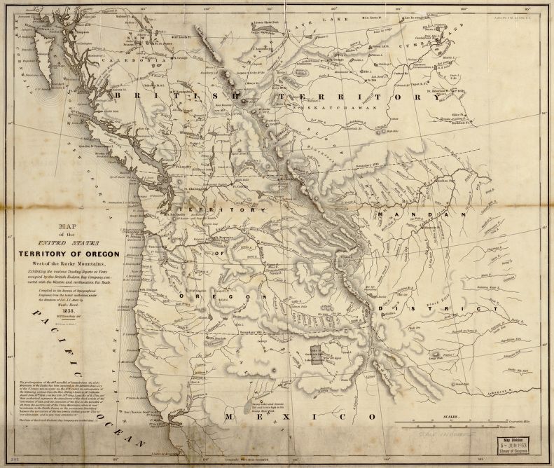
Renewed congressional activity on the desirability of occupying the Oregon Territory began to include maps. In 1838, Senator Lewis Linn presented a bill to Congress to authorize the president to occupy the area. The bill was accompanied by a Map of the United States Territory of Oregon West of the Rocky Mountains, drawn by Washington Hood of the Corps of Topographical Engineers. The map included text relating to ongoing British and American negotiations on the resolution of the 1818 Joint Occupation of Oregon Country, which focused on the 49th parallel as a boundary between the two nations' claims.
In 1840, the US Senate commissioned Robert Greenhow, librarian to the Department of State, to produce a Memoir of the North West Coast, which contained a map of The North West coast of North America and adjacent territories, drawn by David Burr, geographer to the U.S. House of Representatives.
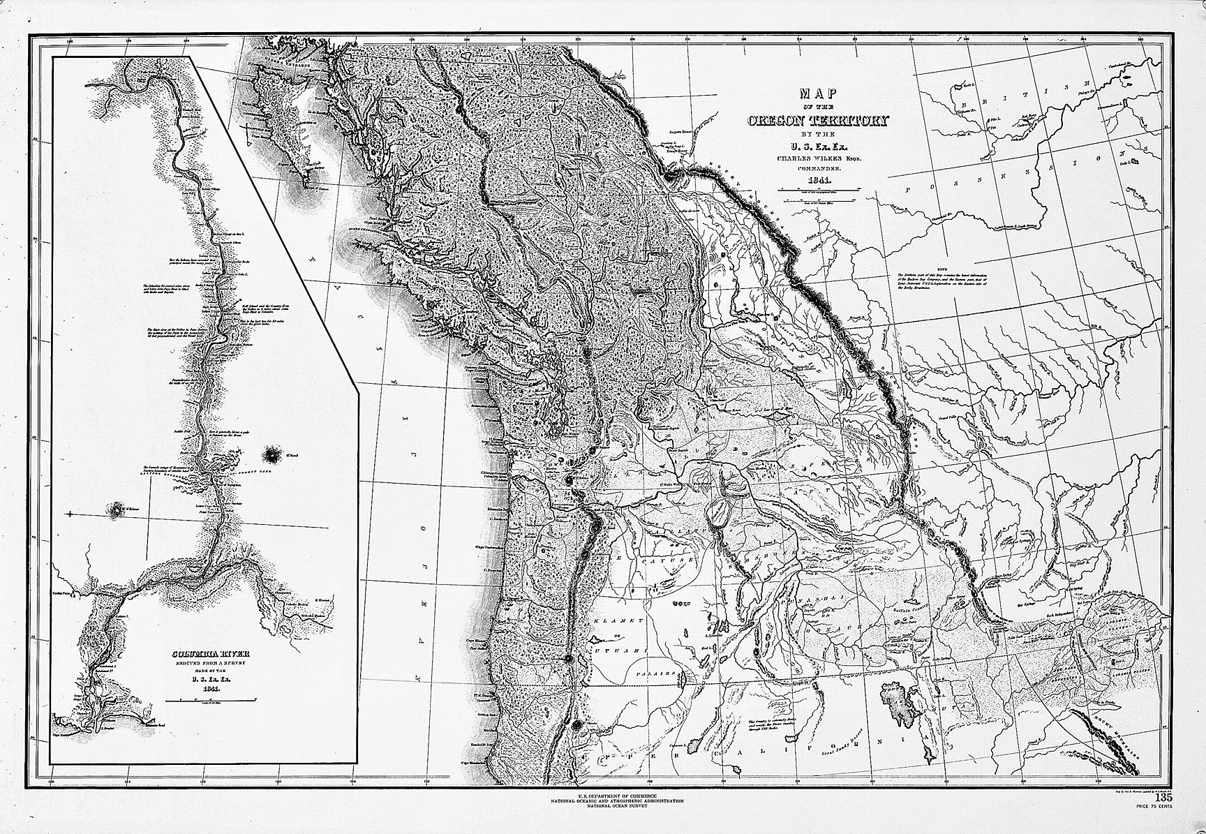
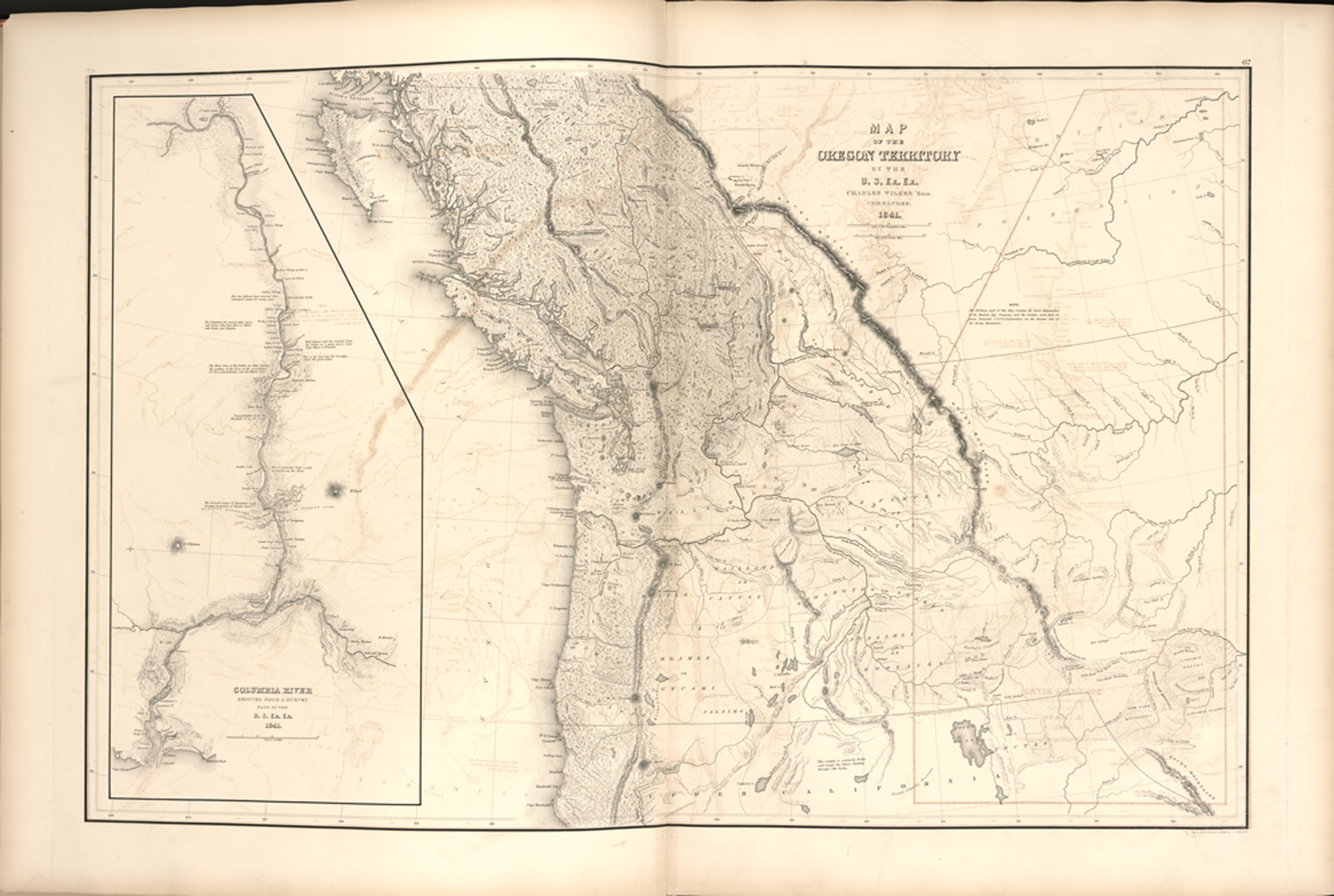
An overland route west to the Oregon Country and early settlement of American emigrants in the Willamette Valley had been established by the time of the U.S Exploring Expedition of 1838–1842, commanded by Lieutenant Charles Wilkes, and the first two Exploring Expeditions of John Charles Frémont ,of the Corps of Topographical Engineers in 1842 and 1843–1844. The cartographic output of both efforts introduced new topographical information on the interior of Oregon and on transportation routes to that region. Wilkes drew his Map of the Oregon Territory in 1841, but publication of the five-volume narrative and atlas was delayed until 1844. That large map included an inset map of the Columbia River surveyed to Fort Walla-Walla, as well as locations of the Willamette Mission and posts of the Hudson’s Bay Company.
Wilkes's map was the most accurate of the time, since it incorporated topographical information from accounts of some of the earliest explorers and trappers in the area. They included Frémont, Jedediah Smith, and Peter Skene Ogden. Ogden's extensive forays into the Snake River country in the late 1820s were set down in 1834 on British North America, a map by John Arrowsmith, which in turn was used by Wilkes.
The results of Frémont’s expedition in Oregon were incorporated into three maps drawn by Frémont and Charles Preuss, which were published in different formats over four years. In 1845, the Map of the Exploring Expedition appeared with Frémont’s report in Congress. According to Wheat, the map “radically and permanently altered western cartography.” By order of the Senate in 1846, Preuss published his Topographical Map of the Road from Missouri to Oregon. This heavily annotated seven-section map, on a scale of one inch to ten miles, was a “road guide for Oregon emigrants such as had never been published.”
In 1848, Frémont and Preuss published a Geographical Memoir as a Senate document, which included a magnificent Map of Oregon and Upper California. Although the map contained erroneous information on the geography of the Great Basin, it incorporated useful information from a variety of sources, including Frémont’s third expedition into California in 1845–1846. It was also, perhaps, the earliest map to contain geographic information on the discovery of gold in California. Because of its extensive distribution, it was probably the most visible delineation of the Oregon Territory in the year of its establishment.
Two additional maps of this period should be mentioned because of their elegant graphics, the nature of information contained within, and the extent of their distribution. In 1840–1842, Eugene Duflot de Mofras was dispatched by the French government on a reconnaissance to settlements in the Pacific Northwest. He traveled extensively in the interior of Oregon and was impressed by the numbers of settlers of French heritage. His report was published in Paris in 1844 and included Carte de la cote de L’Amerique. The map “was a landmark," Wheat noted, “not so much for its geography as because it made those western regions known in European official circles, where his book was widely read.” The map was beautifully engraved and replete with information, including locations of Willamette Valley white settlements, Indian nations, transportation routes, and northern boundaries disputed by British and American statesmen during negotiations from 1818 to 1846. In 1846, the dispute was settled when the 49th parallel was established as the northern boundary of Oregon Territory.
Perhaps the first commercial cartographer to incorporate this information was Samuel Augustus Mitchell, whose A New Map of Texas, Oregon and California was published in 1846 with a booklet that described geographies of territories. The elegantly designed and colored map contained much topographical detail and clearly delineated the multiple boundaries proposed over the years. As a commercial product of an established Philadelphia-based publisher, the map enjoyed widespread diffusion and popularity.
-
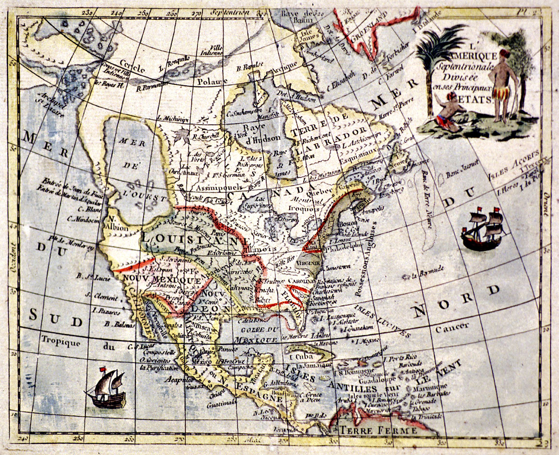
![]()
L"Amerique Septentrionale, c. 1750s.
Courtesy Oreg. Hist. Soc. Research Library, Map365
-
![Oregon and Upper California, 1848, by Charles Preuss.]()
Oregon and Upper California, 1848.
Oregon and Upper California, 1848, by Charles Preuss. Courtesy Oreg. Hist. Soc. Research Library, Map265A
-
![Tartariae sive Magni Chami Regni tÿpus, 1603, by Abraham Ortelius.]()
Ortelius map, 1603.
Tartariae sive Magni Chami Regni tÿpus, 1603, by Abraham Ortelius. Courtesy Library of Congress
-
![]()
World map by Martin Waldseemuller, 1507.
Courtesy Library of Congress
-
![Historia general de los hechos de los castellanos en las Islas i Tierra Firme del Mar Oceano, 1601, by Antonio de Herrera y Terdesillas.]()
Terdesillas map, 1601.
Historia general de los hechos de los castellanos en las Islas i Tierra Firme del Mar Oceano, 1601, by Antonio de Herrera y Terdesillas. Courtesy Library of Congress
-
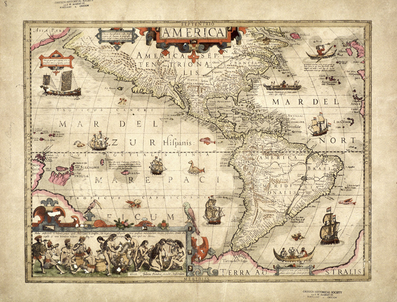
![Map of the Americas, 1606, by Jodocus Hondius.]()
Map of the Americas, 1606.
Map of the Americas, 1606, by Jodocus Hondius. Courtesy Oreg. Hist. Soc. Research Library, Map008
-
![Lewis and Clark, "Track Across the Western Portion of North America, " published in 1814.]()
Lewis and Clark Expedition map.
Lewis and Clark, "Track Across the Western Portion of North America, " published in 1814. Courtesy Oreg. Hist. Soc. Research Library, CN054377
-
![]()
A Map of North America, 1822, by H.S. Tanner.
Courtesy David Rumsey Historical Map Collection
-
![]()
U.S. Territory of Oregon, West of the Rocky Mountains, 1838.
Courtesy Oreg. Hist. Soc. Research Library, OrHi99317
-
![Map of the United States of North America with parts of the adjacent countries, 1839, by David Burr.]()
Burr map.
Map of the United States of North America with parts of the adjacent countries, 1839, by David Burr. Courtesy Library of Congress
-
![Map of the United States, Territory of Oregon, 1838, by Washington Hood.]()
Hood map, 1838.
Map of the United States, Territory of Oregon, 1838, by Washington Hood. Courtesy Library of Congress
-
![Oregon Territory Exploring Expedition, 1841, Charles Wilkes Expedition.]()
Wilkes map, 1841.
Oregon Territory Exploring Expedition, 1841, Charles Wilkes Expedition. Courtesy Oreg. Hist. Soc. Research Library, OrHi86847
-
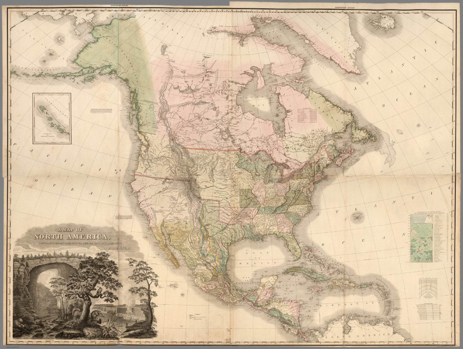
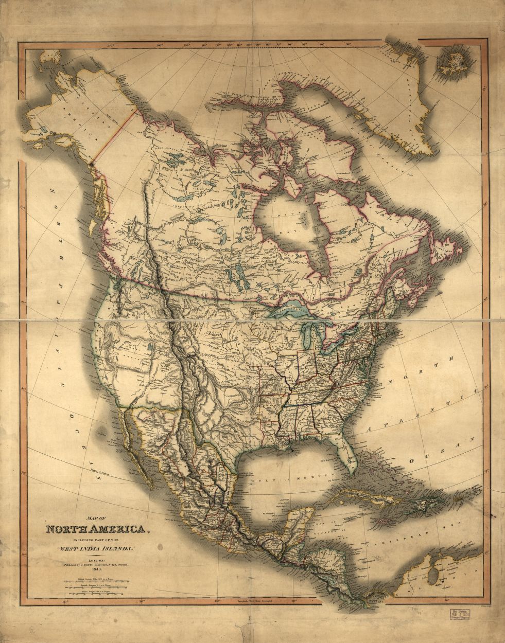
![Map of North America, 1849, by Charles Smith]()
Map of North America, 1849.
Map of North America, 1849, by Charles Smith Courtesy Library of Congress
-
![]()
A map of America between latitudes 40 and 70 north....Mackensie's track, 1793.
Courtesy Library of Congress


Related Entries
-
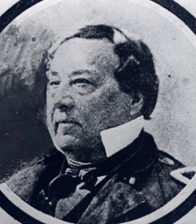
![Benjamin Bonneville (1796-1878)]()
Benjamin Bonneville (1796-1878)
In a journey that spanned three years, Benjamin Louis Eulalie de Bonnev…
-
![Bruno de Hezeta y Dudagoitia (1744-1807)]()
Bruno de Hezeta y Dudagoitia (1744-1807)
Bruno de Hezeta y Dudagoitia, a Spanish naval officer, commanded an exp…
-
![George Vancouver (1757-1798)]()
George Vancouver (1757-1798)
The role George Vancouver played in Oregon history is tangential, yet i…
-
![James Cook (1728-1779)]()
James Cook (1728-1779)
In the lower right-hand corner of his magnificent Chart of the NW Coast…
-
![Lewis and Clark Expedition]()
Lewis and Clark Expedition
The Expedition No exploration of the Oregon Country has greater histor…
-
![Robert Gray (1755–1806)]()
Robert Gray (1755–1806)
On May 11, 1792, Robert Gray, the first American to circumnavigate the …
-
![United States Exploring Expedition (1838-1842)]()
United States Exploring Expedition (1838-1842)
The United States Exploring Expedition (1838-1842), also known as the W…
Related Historical Records
Further Reading
Burden, Philip. The Mapping of North America: A List of Printed Maps 1511-1670. London: Raleigh Publications, 1996.
Hayes, Derek. Historical Atlas of the Pacific Northwest. Seattle: Sasquatch Books, 1999.
Lang, William L., and James V. Walker. Explorers of the Maritime Pacific Northwest: Mapping the World through Primary Documents. Santa Barbara, CA: ABC-Clio, 2016.
Ristow, Walter. American Maps and Mapmakers. Detroit, MI: Wayne State University Press, 1985.
Schwartz, Seymour, and Ralph Ehrenberg. The Mapping of America. New York: Harry Abrams, 1980.
Wagner, Henry. The Cartography of the Northwest Coast of America to the Year 1800. Reprint, 1937. Amsterdam: N. Israel, 1968.
Wheat, Carl. Mapping the Transmississippi West. San Francisco, CA: Institute of Historical Cartography, 1959.