The Christmas Valley Air Force Station, established in the late Cold War era, was a 2,622-acre site located 16 miles east of Christmas Valley. The facility was the transmitting unit of a radar defense system and was composed of 216 antennae that range from 35 to 135 feet high.
The station was the product of research in an over-the-horizon backscatter radar (OTH-B) system that had been developed in the early 1970s at the Air Force Rome Air Development Center, a research center in New York. The OTH-B system was to provide long-range (up to 3,300 km) radar coverage for U.S. air defense. By bouncing radar beams off the atmosphere, the system was designed to detect inbound missiles or bombers launched by hostile forces.
In 1983, due to its remote location and electromagnetically quiet characteristics, the Christmas Valley site was selected to function as the transmitter station for the West Coast Sector of the radar system, with the associated receiver located in Tule Lake, California. The 777th Radar Squadron was to operate the sector, based out of Mountain Home Air Force Base in Idaho.
After consultations with local residents on size, facilities, and environmental impact—determined to be “not significant”—construction of the Christmas Valley facility was approved. General Electric Aerospace eventually spent around $275 million on the site’s construction.
The completed transmitter in Oregon and the receiver in California were turned over to the Department of Defense in late 1990 to test and evaluate. The end of the Cold War, however, ensured that the system would never enter full service. The local community was disappointed at the site’s reduced status. Site construction and maintenance had provided local jobs, and most military personnel and their families left the area.
The Christmas Valley facility officially entered "warm-storage" in 1997, which meant the station could become operational within a 24-month recall period. In 2002, the facility entered "cold-storage," when most equipment was removed from the facility and stored off-site. Three years later, Christmas Valley Air Force Station was officially closed.
The Burns Paiute and Klamath tribes made requests for the land, but the Bureau of Land Management did not pursue them. Instead, in cooperation with the State of Oregon, the BLM explored joint use of the site for renewable energy generation and emergency management facilities. One area of the site, now divided into two sections, is administered by the Oregon National Guard and has become a storage area for emergency management supplies.
The high-capacity transmission lines originally installed for the radar transmitter have made the site an attractive option for renewable energy generation. With support from the Christmas Valley Chamber of Commerce, the state-run Oregon Solutions project earmarked the site for development in 2010. As of 2011, construction of solar and wind generators remained in the planning stage.
-
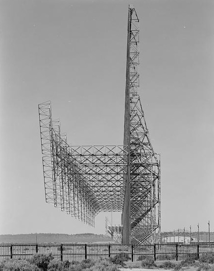
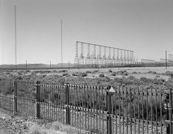
![OTH-B radar network, Christmas Valley Air Force Station, Oct. 2005.]()
Christmas Valley Air Force Station, OTHB antennas 1.
OTH-B radar network, Christmas Valley Air Force Station, Oct. 2005. Photo Robert Hicks, Libr. of Congr., Prints and Photo Div., Historic American Bldgs Survey, Historic American Eng. Record, OR-154-B-2
-
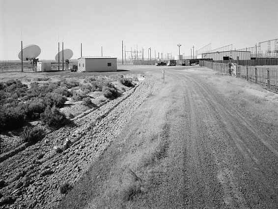
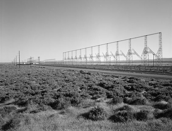
![Christmas Valley Air Force Station, Oct. 2005.]()
Christmas Valley Air Force Station, OTHB facility from road.
Christmas Valley Air Force Station, Oct. 2005. Photo Robert Hicks, Libr. of Congr., Prints and Photo Div., Historic American Bldgs Survey, Historic American Eng. Record, OR-154-C-1
-
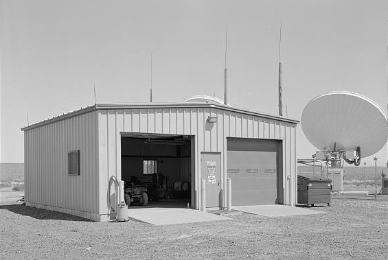
![Garage at Christmas Valley Air Force Station, Oct. 2005.]()
Christmas Valley Air Force Station, shed.
Garage at Christmas Valley Air Force Station, Oct. 2005. Photo Robert Hicks, Libr. of Congr., Prints and Photo Div., Historic American Bldgs Survey, Historic American Eng. Record, OR-154-E-1
-
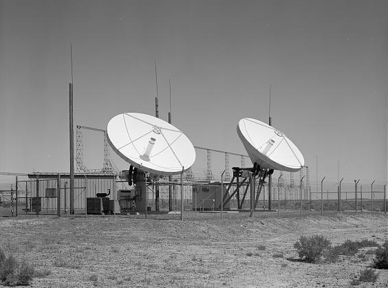
![Communications antennas at Christmas Valley Air Force Station, Oct. 2005.]()
Christmas Valley Air Force Station, satellite dishes.
Communications antennas at Christmas Valley Air Force Station, Oct. 2005. Photo Robert Hicks, Libr. of Congr., Prints and Photo Div., Historic American Bldgs Survey, Historic American Eng. Record, OR-154-G-1
-
![OTH-B radar network, Christmas Valley Air Force Station, Oct. 2005.]()
Christmas Valley Air Force Station, OTHB antennas 4.
OTH-B radar network, Christmas Valley Air Force Station, Oct. 2005. Photo Robert Hicks, Libr. of Congr., Prints and Photo Div., Historic American Bldgs Survey, Historic American Eng. Record, OR-154-F-1
-
![OTH-B radar network, Christmas Valley Air Force Station, Oct. 2005.]()
Christmas Valley Air Force Station, OTHB antennas 3.
OTH-B radar network, Christmas Valley Air Force Station, Oct. 2005. Photo Robert Hicks, Libr. of Congr., Prints and Photo Div., Historic American Bldgs Survey, Historic American Eng. Record, OR-154-N-3
-
![OTH-B radar network, Christmas Valley Air Force Station, Oct. 2005.]()
Christmas Valley Air Force Station, OTHB antennas 2.
OTH-B radar network, Christmas Valley Air Force Station, Oct. 2005. Photo Robert Hicks, Libr. of Congr., Prints and Photo Div., Historic American Bldgs Survey, Historic American Eng. Record, OR-154-I-3

Related Entries
-
![McCarthy Era (late 1940s-late 1950s)]()
McCarthy Era (late 1940s-late 1950s)
As Woody Guthrie observed at the dawn of the McCarthy Era in 1947, "Por…
-
![Operation Red Hat]()
Operation Red Hat
Operation Red Hat was the label the American military applied broadly t…
-
![Portland Civil Defense]()
Portland Civil Defense
In response to perceived Cold War threats, on February 20, 1950, Mayor …
-
![Umatilla Army Depot]()
Umatilla Army Depot
In 1940, the U.S. Army identified twenty thousand acres straddling the …
-
![U.S. Bureau of Land Management]()
U.S. Bureau of Land Management
The Bureau of Land Management (BLM) administers over 15.7 million acres…

Related Historical Records
Map This on the Oregon History WayFinder
The Oregon History Wayfinder is an interactive map that identifies significant places, people, and events in Oregon history.
Further Reading
Chu, Keith. "If a Disaster Hits Oregon, Christmas Valley Could be a Refuge." The Bend Bulletin, March 15, 2009. http://www.bendbulletin.com/apps/pbcs.dll/article?AID=/20090315/NEWS0107/903150427/1041.
Winkler, David F. Searching the Skies: the Legacy of the United States Cold War Defense Radar Program. Prepared for United States Air Force Headquarters Air Combat Command. Langley AFB, Va.: Headquarters Air Combat Command, 1997.