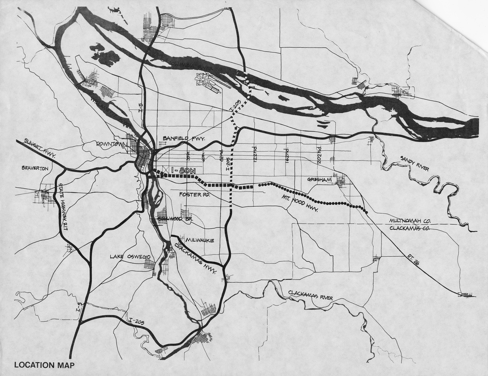
The Mount Hood Freeway, if constructed, would have passed through southeast Portland, from the Marquam Bridge at the Willamette River to about S.E. 122nd Avenue. Changes in political leadership coupled with new federal environmental legislation and grass-roots opposition prevented the freeway's approval and construction.
The Oregon State Highway Department originated plans for the Mount Hood Freeway in 1955 as part of a report that recommended fourteen new freeways for the Portland area. The construction of Interstates 5, 405, and 205 were given priority. Financing the proposed Mount Hood route proved challenging, and it was not until 1969 that it seemed the Mount Hood Freeway would actually be constructed.
In a deal with the federal Bureau of Public Roads, the Mount Hood Freeway was granted status as Interstate 80 North, a designation previously belonging to the twisty and narrow Banfield Freeway in northeast Portland. With interstate status, the new freeway could be constructed with 92 percent of the $75 million costs coming from federal coffers.
Like many planned urban freeways constructed during this era, the Mount Hood Freeway met significant opposition. Early opposition came from long-time residents living on or near the proposed route. But freeway opponents remained relatively weak and lacked formal organization until federal environmental legislation in the 1970s provided new means to delay the freeway's construction.
A new generation of public officials—led by Portland City Council member (and then Mayor) Neil Goldschmidt, and Multnomah County Commissioners Don Clark and Mel Gordon—publicly expressed their desire to rejuvenate Portland's downtown core, clean up its air, and expand the new public mass-transit system, Tri-Met. The National Environmental Protection Act of 1969 (NEPA) and the Federal Clean Air Act of 1970 proved to be tremendous hurdles for the Mount Hood Freeway to overcome. An environmental impact statement (EIS), required by NEPA, pointed out deficiencies in the freeway's design. Not only would the freeway have traffic that exceeded its capacity, but the Marquam Bridge was inadequate; there would have to be a supplemental river crossing over the Willamette. Estimated costs skyrocketed, and public opposition increased.
The Mount Hood Freeway also met significant legal opposition. In 1972, grass-roots opponents of the freeway, calling themselves Southeast Legal Defense, filed several claims against state highway officials in an effort to stop the freeway's construction and the state's purchase of right-of-way property. In February 1974, U.S. District Court Judge James Burns ruled that the route for the freeway had been selected illegally and halted further development.
Soon afterward, Multnomah County officially withdrew its support for the freeway, with the City of Portland following suit in July 1974. A move to allow voters to decide the fate of the freeway was subsequently ruled invalid. Under the provisions of the 1973 Federal Aid Interstate Highway Act, the state was allowed to request an exchange of Interstate Highway funds for federal dollars that could be used on mass transit and road improvement projects.
In 1976, the U.S. Department of Transportation agreed to exchange the approximately $180 million, once targeted for the construction of the freeway, for a similar amount that could be used on other transportation projects, including mass transit. The Mount Hood Freeway was then officially removed from the Interstate Highway System. Over the next decade and a half, funds once designated to build the most controversial road in Portland's history were used elsewhere in the Portland area, including on the city's first MAX light-rail line.
-
Mount Hood Freeway map.
Image from publication "I-205 and Mount Hood Freeways: Facts and Alternatives." Proposed freeway is signified by dashed line running horizontally in center of image. Oreg. Hist. Soc. Research Lib., bb005623
Related Entries
-
Columbia River Highway
The Columbia River Highway, now known as the Historic Columbia River Hi…
-
![Interstate 5 in Oregon]()
Interstate 5 in Oregon
Interstate 5 is a 308-mile-long segment of highway that runs between th…
-
![Neil Goldschmidt (1940-2024)]()
Neil Goldschmidt (1940-2024)
Neil Edward Goldschmidt, the thirty-third governor of Oregon (1986-1991…
Related Historical Records
Map This on the Oregon History WayFinder
The Oregon History Wayfinder is an interactive map that identifies significant places, people, and events in Oregon history.
Further Reading
Abbott, Carl. Portland: Planning, Politics, and Growth in a Twentieth-Century City. Lincoln: University of Nebraska Press, 1983.
Oregon State Highway Department. Freeway and Express System, Portland Metropolitan Area, 1955. Salem: Oregon State Highway Department, 1955.
Portland Planning Commission. Mt. Hood Freeway: Report to the Portland City Council. Portland: Planning Commission, 1965.


