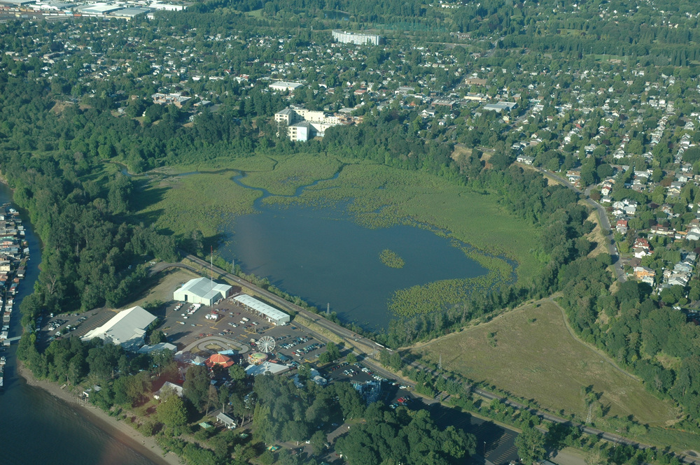
Oaks Bottom, Portland’s first urban wildlife refuge, is located on the east bank of the Willamette River opposite the upstream tip of Ross Island. More than 120 migratory or resident species of birds use the Bottom, including bald eagles, peregrine falcons, red-tailed hawks, merlin, and sharp-shinned and Cooper's hawks. Mammals include river otter, muskrat, beaver, the non-native nutria, raccoon, and even deer and bobcat.
Beginning in the late 1960s, before the area became known as Oaks Bottom, the Audubon Society of Portland, the Sierra Club, the Nature Conservancy, and the Sellwood-Moreland Improvement League (SMILE) petitioned the city to designate Oaks Bottom as an official wildlife refuge. The group asked that the area be named Wapato Wildlife Refuge after the wetland plant that Native Americans called wapato, or Indian potato. In the late 1960s, the area was slated for industrial development. Rubble from the destruction of the Stadium Freeway was deposited in the north wetlands, and the south end was a smoldering garbage heap.
SMILE took the lead in advocating for Oaks Bottom as a natural area for the city, largely to combat the spread of noisy motorcycles. Portland Parks had plans to site the Children's Museum and carve out a ten-acre motorcycle facility in the Bottom, a proposal that was quickly rescinded under a torrent of neighborhood opposition.
In 1972, Portland State University urban studies students embarked on a project to develop four scenarios for Oaks Bottom. This was followed by a recommendation that the city lease Oaks Bottom to the Audubon Society of Portland, which would manage the wetlands and riparian areas and leave the north and south fills open to other recreational uses. Audubon countered that the entire Bottom should be a wildlife refuge.
Throughout the long-running debate over the fate of Oaks Bottom, which continued from the mid-1960s until the late 1980s, Portland's Bureau of Parks and Recreation was undergoing its own policy and philosophical evolution regarding the importance of natural areas in its more than 10,000-acre park system. Under the leadership of City Commissioner Mike Lindberg in the 1980s, park staff such as Jim Sjulin, Steve Bricker, and Fred Nielsen increasingly focused attention on the acquisition and management of natural areas.
In 1988, the Portland City Council adopted the Oaks Bottom Coordinated Resource Management Plan, which laid out a variety of management objectives. Ecologists from Portland Parks and Recreation and the Bureau of Environmental Services, the Audubon Society of Portland, the Urban Greenspaces Institute, and others are developing an adaptive management approach to improve fish and wildlife habitat and create more wildlife viewing opportunities in the Bottom. Controlled burns are now used to manage invasive species and diversify habitat. Himalayan blackberry, English ivy, and clematis have been removed and replaced with grasses and native plants along the steep slopes and in the Bottom.
While numerous problems remain, Oaks Bottom Wildlife Refuge's future as one of the region's significant urban wildlife and nature-viewing areas is secure.
-
![Oaks Bottom Wildlife Refuge.]()
Oaks Bottom Wildlife Refuge, aerial, DSC_0542.
Oaks Bottom Wildlife Refuge.
Related Entries
-
![Portland]()
Portland
Portland, with a 2020 population of 652,503 within its city limits and …
-
![Portland State University]()
Portland State University
Located in downtown Portland, Portland State University is Oregon’s urb…
-
Willamette River
The Willamette River and its extensive drainage basin lie in the greate…
Map This on the Oregon History WayFinder
The Oregon History Wayfinder is an interactive map that identifies significant places, people, and events in Oregon history.
Further Reading
Houck, Michael C. and M.J. Cody. Wild in the City, A Guide to Portland's Natural Areas. Portland, Ore.: Oregon Historical Society Press, 2000.
Wild on the Willamette, Exploring the Lower Willamette River. Portland, Ore.: Audubon Society of Portland and Urban Greenspaces Institute, 2003.


