The Applegate Trail, first laid out and used in 1846, was a southern alternative to the western-most segment of the Oregon Trail, with its users leaving the original Oregon City-bound Oregon Trail route near Ft. Hall, in what is now southeastern Idaho, and following the California Trail west along the Humboldt River, to where the Applegate Trail branched off to the northwest. Conceived as being safer, quicker, and more secure from possible British control should war break out over the Oregon Question, the trail (which was also known to Oregonians as Applegate's Cut-off, the Southern Emigrant Road, and simply as the South Road or Southern Road during its main period of use, 1846-1860) was intended to bring wagon trains of settlers into the Willamette Valley. Although the number of emigrants who used the Applegate Trail was comparatively modest, it had particular significance in the settling of the Rogue Valley during the 1850s.
The main Oregon Trail followed the Snake River across southern Idaho and then crossed it to enter Oregon near present-day Vale. From there, after an ascent of the Blue Mountains, came the Columbia River stretch of the route, which before 1847 required rafting wagons, goods, and people down the treacherous Columbia; the trip was so dangerous that many people and most animals walked the river bank while a few brave people guided the wagons and possessions down the river. In 1843, the Applegate brothers, heading to Oregon from Missouri, lost two family members in the waters of the river. (After 1846 the main Oregon Trail included an alternative, slower if safer route by land, crossing the Columbia Plateau south of the river to The Dalles; on this route the oxen could pull fully loaded, and by now quite decrepit, wagons along the rugged and slow course that paralleled the river.)
In mid-June, 1846, a group of fifteen Willamette Valley settlers met at Rickreall Creek near Dallas, in Polk County, and started southward to blaze the new route. The party included Levi Scott, David Goff, John Owen, and the Applegate brothers, Jesse and Lindsay. (Because of Scott's importance in the endeavor, the route could better be called the Applegate-Scott Trail.) Although the route from the Oregon settlements south to the California border was by then relatively well known if not heavily traveled, the men had little or no first-hand knowledge of the area east of the Rogue Valley their new trail would traverse.
Eastward over the Cascade Range and beyond Lower Klamath Lake the route they blazed crossed northeastern California's rugged volcanic Modoc Plateau to Goose Lake. From there they crossed the Warner Mountains' Fandango Pass and continued over the desolate Black Rock Desert, until the new "cut-off" joined the well traveled California Trail along northern Nevada's Humboldt River (the junction was located beneath what is now the northern tip of Rye Patch reservoir). For much of the new route's length, it passed through parched country—a sea of sagebrush. While most of the men stayed on the Humboldt to rest their horses and await the first travelers, Jesse Applegate continued east to Ft. Hall, arriving by early August, to promote the new route to Oregon-bound emigrant trains— and it was largely due to this that the trail soon came to bear his name.
Applegate's description persuaded a number of groups to cut off from the main Oregon Trail and try the new route, much of which had hardly been marked, let alone cleared. The going was slow and rough; the trains were subjected to intermittent harassment by Paiute and Modoc Indians almost all the way west to the Rogue Valley. Even north of there, along the Oregon-California trail, the steep forested defile of Douglas County's Canyon Creek proved extremely difficult for loaded wagons. One 1846 emigrant, J. Quinn Thornton, became so enraged by the travails that he subsequently wrote and published a stream of vicious personal attacks against Jesse Applegate and "his trail." In 1847 Levi Scott returned to improve the trail. During this and following years, some Willamette Valley-bound travelers took note of the rich soil and mild weather of the Rogue River country, returning there in the early 1850s to claim homesteads under the Donation Land Act. In 1853, despite the killing of emigrants at "Bloody Point" (near Tule Lake) by Modoc Indians the previous year, some 3,000 people used the Applegate Trail, and for many of them the as-yet barely settled farmland of southwestern Oregon was the goal—literally the end of the trail.
Jackson County's Emigrant Creek was named for the trail's several crossings of that stream as travelers descended the Cascade Range into the Rogue Valley near Ashland. Today, portions of the Applegate Trail in Oregon are closely paralleled by Interstate Highway 5 and State Highway 66. The National Park Service designated the Applegate Trail as a National Historic Trail in 1992 (as a part of the larger California Trail). The sesquicentennial in 1996 entailed re-enactments and other festivities.
One outgrowth of that observance was the development of the Applegate Trail Interpretive Center and Museum, located on Grave Creek (named for a young emigrant woman who died of typhoid fever and was buried nearby), north of Grants Pass. Although the facility's visitation numbers have not met the promoters' original expectations, it is a worthy stop located just off Interstate 5 at the Sunny Valley exit.
-
![]()
Map of the Applegate Trail (Southern Route).
Courtesy National Park Service
-
![]()
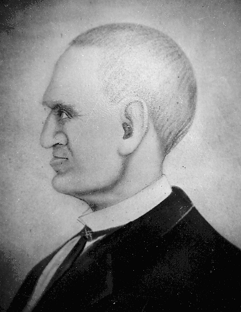
Jesse Applegate.
Oreg. Hist. Soc. Research Lib., OrHi 45
-
![]()
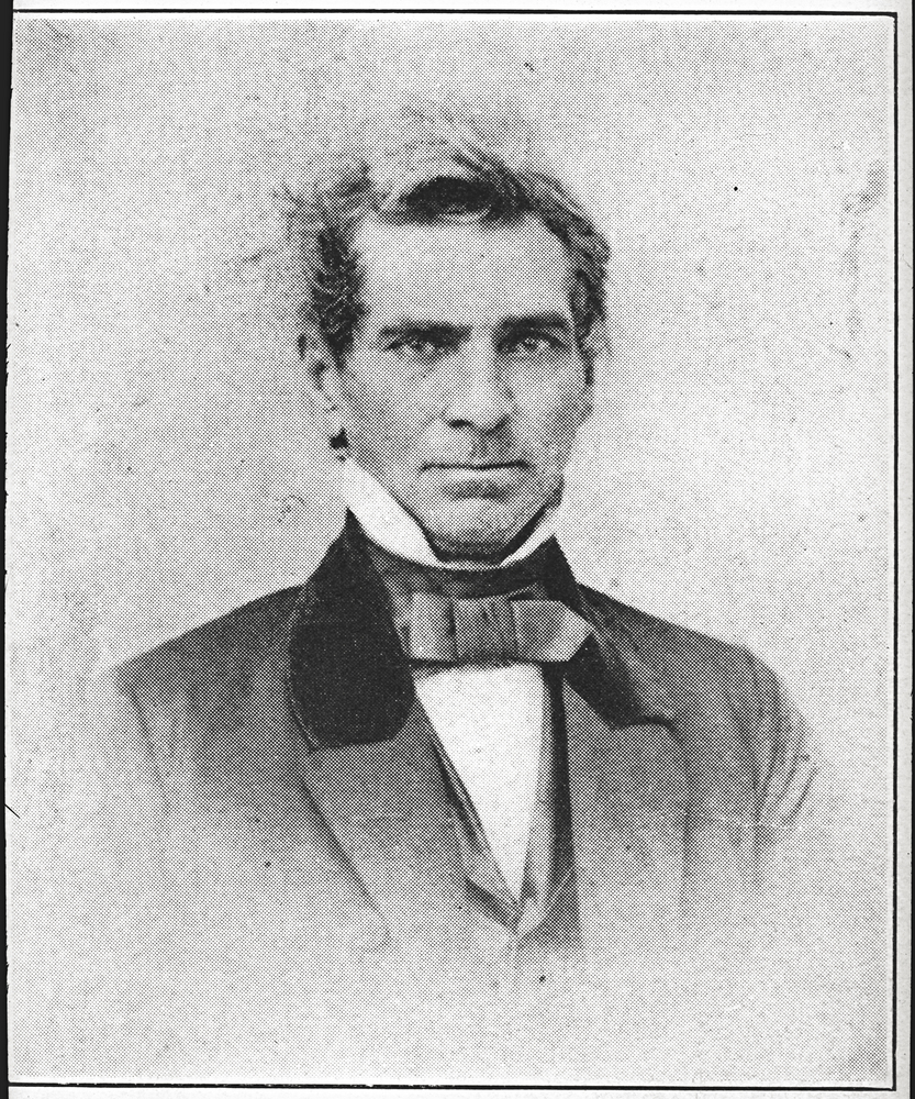
Lindsay Applegate.
Oreg. Hist. Soc. Research Lib., bb004177
-
![]()
Main street in Fort Bidwell, part of the Applegate Trail, California, 1886.
Oregon Historical Society Research Library, 002794
-
![]()
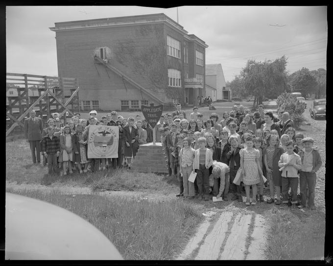
Applegate Trail marker observance, 1948.
Courtesy Oregon State University Libraries
-
![]()
Transcription of cover letter of March 20, 1848, from Jesse Applegate to Gov. George Abernethy.
Transcription Stafford Hazelett
-
![]()
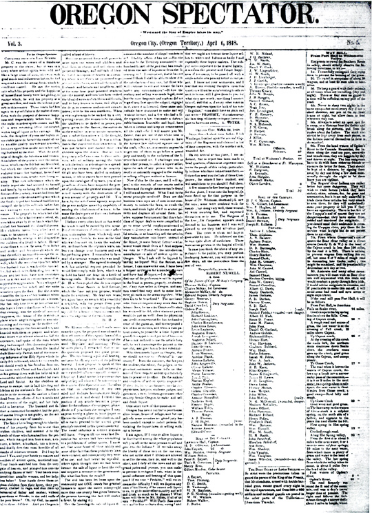
Oregon Spectator, April 6, 1848.
Oreg. Hist. Soc. Research Lib.
-
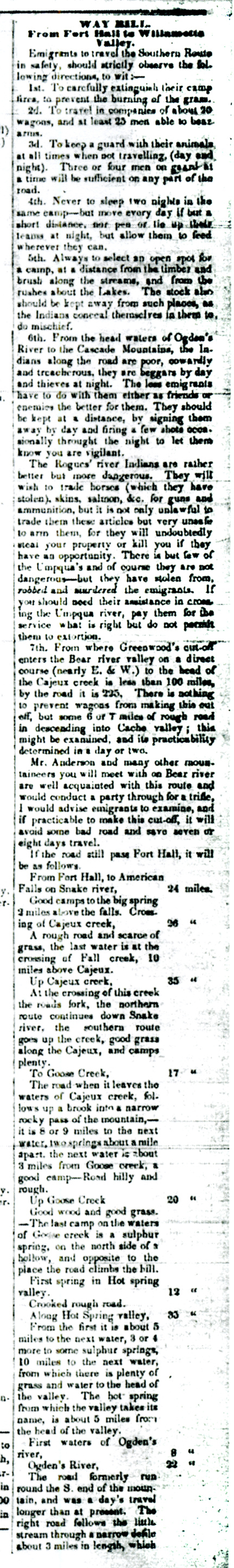
![First part of Levi Scott's Applegate Trail waybill, published in Oregon Spectator of Apr 6, 1848.]()
Oregon Spectator, Apr 6 1848, detail.
First part of Levi Scott's Applegate Trail waybill, published in Oregon Spectator of Apr 6, 1848. Oreg. Hist. Soc. Research Lib.
-
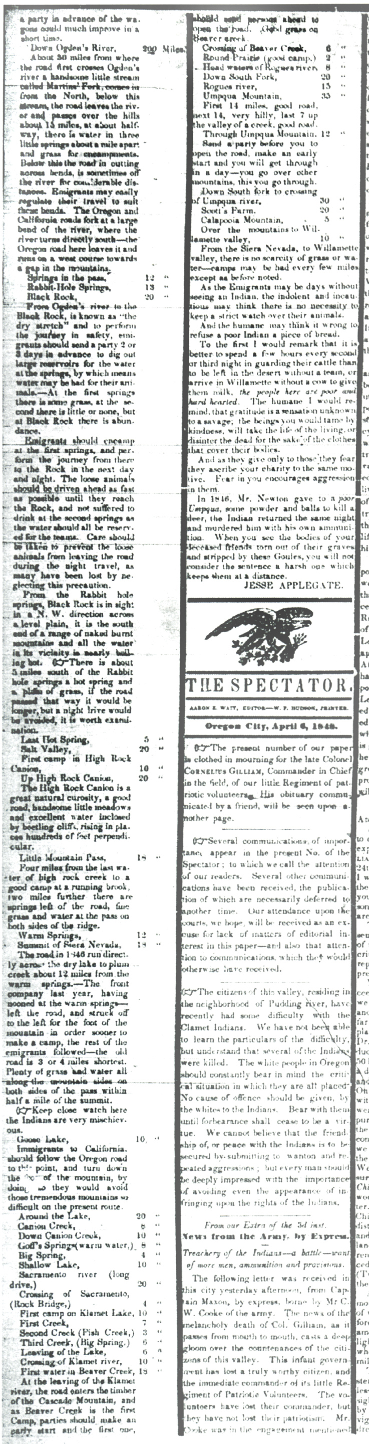
![Second part of Levi Scott's Applegate Trail waybill, published in Oregon Spectator of Apr 6, 1848.]()
Oregon Spectator, April 6 1848, detail.
Second part of Levi Scott's Applegate Trail waybill, published in Oregon Spectator of Apr 6, 1848. Oreg. Hist. Soc. Research Lib.
-
![Cover letter from Jesse Applegate to George Abernethy, March 20, 1848, accompanying Levi Scott's waybill from Ft. Hall to the Willamette Valley published in the Oregon Spectator of April 6, 1848.]()
Applegate to Abernethy, Mar 20 1848.
Cover letter from Jesse Applegate to George Abernethy, March 20, 1848, accompanying Levi Scott's waybill from Ft. Hall to the Willamette Valley published in the Oregon Spectator of April 6, 1848. Oreg. Hist. Soc. Research Lib., MSS 929


Related Entries


Related Historical Records
Map This on the Oregon History WayFinder
The Oregon History Wayfinder is an interactive map that identifies significant places, people, and events in Oregon history.
Further Reading
Beckham, Stephen Dow. "Applegate Trail: Impressions and Experiences of Emigrants and Other Travelers." (prepared for the Applegate Trail Coalition: 1995).
Francis D. Haines, "The Applegate Trail: Southern Emigrant Route, 1846." (Medford: 1976).
Smith, Ross A. “The Southern Route Revisited.” Oregon Historical Quarterly 105:2 (Summer 2004), 292-307.