Siskiyou Pass, including the 4,310-foot-high Siskiyou Summit of Interstate-5 that is located a short distance east of the original historic pass, is the highest and most historically significant mountain crossing on the main transportation route that links California and Oregon. The geographic feature known as Siskiyou Pass/Siskiyou Summit has earned an enduring legacy as both a physical and a psychological barrier between the two states. It receives by far the heaviest use of any pass in Oregon.
The original pass, situated about five miles north of the state line and less than a half-mile west of I-5's Siskiyou Summit, is at an elevation of 4,129 feet. After 1827, the year the first EuroAmericans explored the region, Siskiyou Pass came to be used successively by wagons, stagecoaches, railroads, and finally automobiles traveling the two-lane Pacific Highway (Highway 99)
The original pass crosses the divide between the Rogue and Klamath Rivers at a slight topographic notch formed by the geological contact between the older Siskiyou Mountains to the west and the younger volcanic Cascade Range to the east. Historically, the forbidding east-west-trending barrier that is surmounted by the pass came to be called Siskiyou Mountain and subsequently Siskiyou Mountains. In terms of geology, when applied to the mountains east of the pass, these names are now considered incorrect, but they still appear on some maps for what is actually part of Cascade Range.
Hudson's Bay Company (HBC) fur trader Peter Ogden and his group of trappers, who were traveling from south to north at the time, first crossed Siskiyou Pass in February 1827. Rising immediately west of the pass is a prominent rounded-top mountain, elevation 5,837 feet, now officially named Ogden Hill.
In 1829, Ogden's HBC colleague Alexander Roderick McLeod traveled south from Fort Vancouver through the Rogue River Valley and crossed the pass on his way to trap the streams of northern California. McLeod's disastrous retreat back across the pass during a blizzard contributed to Siskiyou Pass's reputation as a steep and difficult climb and a formidable winter crossing. Although the meaning of the name Siskiyou is uncertain, it is believed to be a Cree Indian word for bob-tailed horse. McLeod's HBC trappers, some of whom were Métis (a person of mixed Indigenous and EuroAmerican ancestry) from present-day Manitoba, applied the name after the bitter 1829 crossing, during which such a horse perished.
By the mid nineteenth century, the original HBC trail over the pass became first a wagon trail and then a stage road, followed by a railroad line. From the 1850s through the 1880s, the snowpack on the pass halted travel between the two states for months at time. From the 1890s through the 1910s, until powerful snowplows pushed by locomotives were used, passenger and freight traffic could be blockaded for weeks. As the highest point on Interstate 5, snowstorms on Siskiyou Summit still pose a major challenge to winter travelers.
In addition to rugged topography and high elevation, violence also has contributed to the reputation of Siskiyou Pass as a daunting barrier. Dating from at least 1841, when an exploring party of the Wilkes Expedition crossed the pass, it became a place where EuroAmerican travelers remained especially alert against Indian attack. The last such skirmishes occurred in the early 1850s. Seven decades later, in October 1923, the three young DeAutremont brothers, intent on robbing the mail car, climbed aboard the locomotive of a southbound Southern Pacific passenger train as it halted at the north portal of Tunnel #13 to check the brakes. During the misnamed "Last Great Train Robbery"—which took place at about the same location as the 1850s episodes—the brothers shot to death three railroad employees and dynamited the mail car, killing the postal clerk inside. They escaped without securing any loot. Today's interstate highway passes within a few hundred feet of the spot, where the original Siskiyou Pass is visible directly above.
Originally, the combination of a steep grade and deep winter snowpack on Siskiyou Pass caused the Oregon & California Railroad to propose a California connection that would have avoided the pass altogether, by building south from Portland and, near Eugene, eastward over Willamette Pass into the gentler terrain of the upper Klamath Basin. With the Umpqua and Rogue valleys already heavily settled by the late 1860s, however, Oregon politicians ensured that the land-grant railroad would take the more difficult but more heavily populated route. In 1887, completion of Tunnel #13 directly beneath Siskiyou Pass finally linked the two states by rail.
During the late 1950s, federal highway engineers made what was essentially the same detour proposal for Interstate 5. Again, the political and economic influence of cities such as Medford and Roseburg won the day. The Southern Pacific Railroad, which had taken over the Oregon and California Railroad's Siskiyou Pass route in the late 1880s, completed its Natron Cut-off over Willamette Pass in the 1920s. This faster, cheaper route, from Eugene and Klamath Falls to Weed, California increasingly diverted more and more rail traffic from the original route. Passenger service ended in the mid-1950s, and freight traffic over the pass steadily dwindled.
In 2024, a limited number of Central Oregon and Pacific railroad trains travel over the pass, primarily carrying lumber, plywood, and other wood products manufactured in southwestern Oregon. A fire in 2003 destroyed many of original creosoted redwood timbers in Tunnel 13, closing it for repairs until 2005. In 2008, the railroad closed the tunnel for seven years to undertake federally funded modifications, including widening the tunnel and using steel-fiber supports and shotcrete to line the walls.
-
![]()
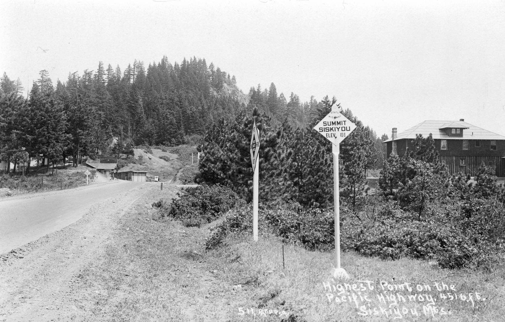
The highest point on the Pacific Highway, 4516 feet, Siskiyou Mountains, c,1930.
Courtesy Frank Patterson Photographs, Oregon State University. "Highest point on the Pacific Highway" Oregon Digital -
![]()
Loop on graded road near Siskiyou Summit. Woman in front of auto in foreground.
Angelus Studio photographs, 1880s-1940s, University of Oregon. "PH037_b156_S00519 Angelus Studio Photographs" Oregon Digital -
![]()
Graded highway at summit of Siskiyou Mountains, looking south toward California.
Courtesy Angelus Studio photographs, 1880s-1940s, University of Oregon. "PH037_b146_S00853 Angelus Studio Photographs" Oregon Digital -
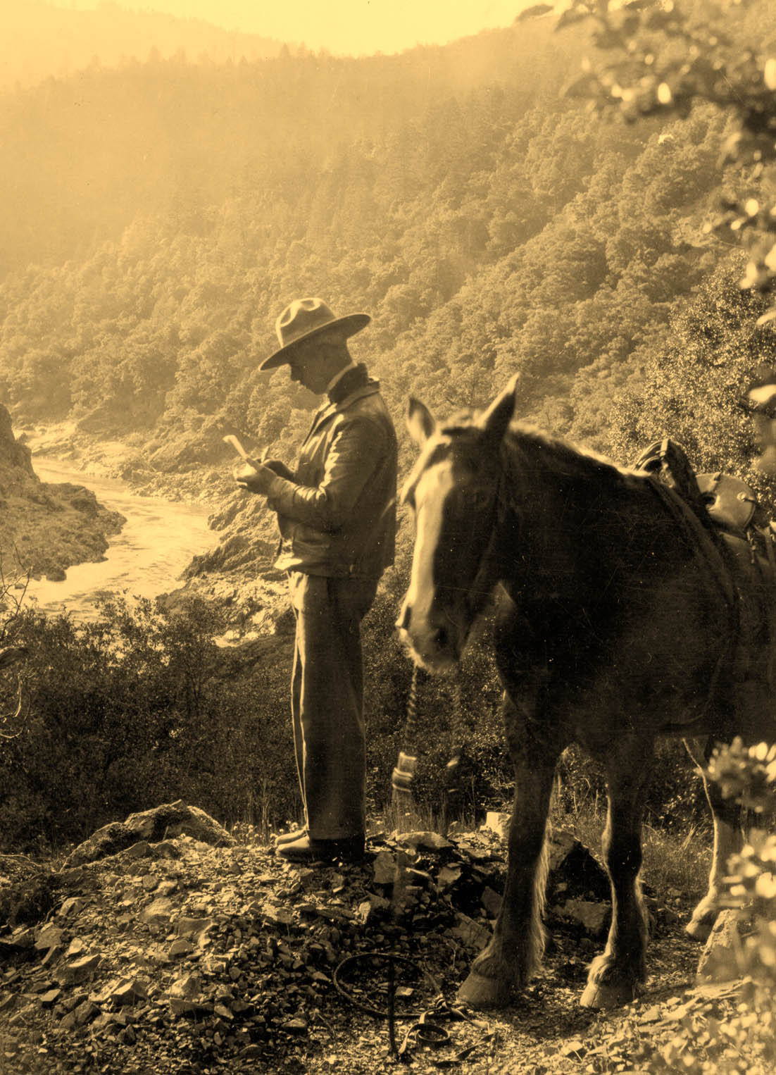
![]()
Trail coming through the Siskiyou Mountains, Oregon, 1910.
Courtesy University of Washington Libraries, Special Collections, AWC9675 -
![]()
Respect the Siskiyou Pass, Oregon Department of Transportation, 2005.
Courtesy State Library of Oregon


Related Entries
-
![DeAutremont Brothers Train Hold-up at Tunnel 13]()
DeAutremont Brothers Train Hold-up at Tunnel 13
The most famous train holdup in Oregon was a ham-fisted disaster. On Oc…
-
![Hudson's Bay Company]()
Hudson's Bay Company
Although a late arrival to the Oregon Country fur trade, for nearly two…
-
![Interstate 5 in Oregon]()
Interstate 5 in Oregon
Interstate 5 is a 308-mile-long segment of highway that runs between th…
-
![Peter Skene Ogden (1790-1854)]()
Peter Skene Ogden (1790-1854)
More than any other figure during the years of the Pacific Northwest's …
-
![Siskiyou National Forest]()
Siskiyou National Forest
The Siskiyou Forest Reserve was created on March 2, 1907; within two da…
-
![Willamette Pass]()
Willamette Pass
Willamette Pass, a 5,128-foot-high mountain pass in the Cascade Range, …

Map This on the Oregon History WayFinder
The Oregon History Wayfinder is an interactive map that identifies significant places, people, and events in Oregon history.
Further Reading
LaLande, Jeffrey M. First Over the Siskiyous: Peter Skene Ogden's 1826-1827 Journey Through the Oregon-California Borderlands. Portland: Oregon Historical Society Press, 1987.
McArthur, Lewis A. and Lewis L. McArthur. Oregon Geographic Names. 7th ed. Portland: Oregon Historical Society Press, 2007.