The town of Champoeg had a brief but memorable life. Instigated by geographic advantage in the 1830s, Champoeg was swept away by devastating Willamette River floods in 1861 and 1862. While the town persisted as a rural riverside community, it failed to recover or to bloom as a center of transportation or industry. Today, the locality is encompassed by the Champoeg State Heritage Area—a state park that displays the town’s history, particularly its place in the story of Oregon’s political development.
The area at the north end of what is today called French Prairie was initially the domain of Kalapuya people, for whom the river was a main transportation route. Trails from the north and south intersected the river there. Those trails were also used by EuroAmerican fur trappers after the Hudson’s Bay Company established Fort Vancouver in 1825. Despite a forty-foot bluff, the site made a good landing point where the wooded river banks gave way to an opening to the prairie land to the south.
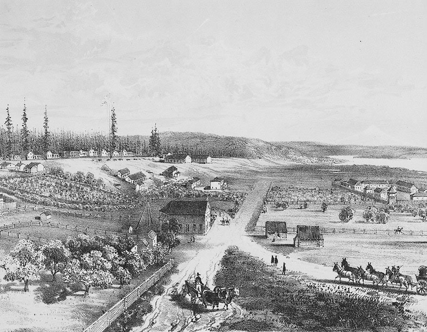
Champoeg (commonly pronounced sham-POO-ee; some locals say sham-POO-eg or -ick) was well known by the early 1840s. It was accessible by water and trails to most of the white settlers in the Willamette Valley, but it was not yet a village. The most prominent structure was a Hudson’s Bay Company warehouse, built in about 1843 to store wheat from French Prairie farmers for shipment downstream. The ease of access at Champoeg and its proximity to many resettlers, however, made it a natural assembly point for what became a sequence of meetings that culminated, in May 1843, in the establishment of the Oregon Provisional Government. That governmental structure lasted until Joseph Lane was appointed governor of Oregon Territory on March 3, 1849.
Fur trapper Robert Newell purchased land at Champoeg from Walter Pomeroy in 1843 or 1844 and began farming. But, as historian John A. Hussey writes, he had a “shining dream in his eyes” of establishing a city. His land adjoined that of André Longtain to the west. Longtain had been farming there since the 1830s, and Jesse Applegate completed a survey of 640 acres for him in 1844. That same year, Newell and Longtain appear to have been selling town lots at Champoeg. Although a formal town plat was not filed until 1853, it is likely that this plat is essentially a copy of one that Applegate had prepared in 1844.
Champoeg was but one of a number of 1840s settlements along the Willamette River that aspired to the city dream, including Linnton, Portland, Oregon City, and Butteville. The influx of American immigrants from 1843 onward propelled those aspirations, and the town of Champoeg grew modestly through the 1850s. Newell put two keelboats, the Mogul and the Ben Franklin, into service between Champoeg and Oregon City in 1845. Michel Laframboise started a ferry service in 1850, and a post office opened that same year. Steamboats worked on the river, and Champoeg benefitted as a landing point with stage connections south to Salem. The settler meetings of 1843-1844 and Indian treaty meetings in 1851 were held there because of the town’s accessibility from points throughout the Willamette Valley.
By the early 1850s, Champoeg had several stores, a livery stable, and a flour mill, yet it “was a straggling settlement of eleven or twelve buildings,” Hussey writes, that were “scattered over the prairie in a thin and wavy line.” By the end of the decade, the fancifully named streets of the town’s plat also boasted a school, several warehouses, saloons, a hotel, an Episcopal church, a blacksmith, and perhaps two dozen or more houses. Perhaps 180 persons lived in Champoeg at the time of the 1860 census.
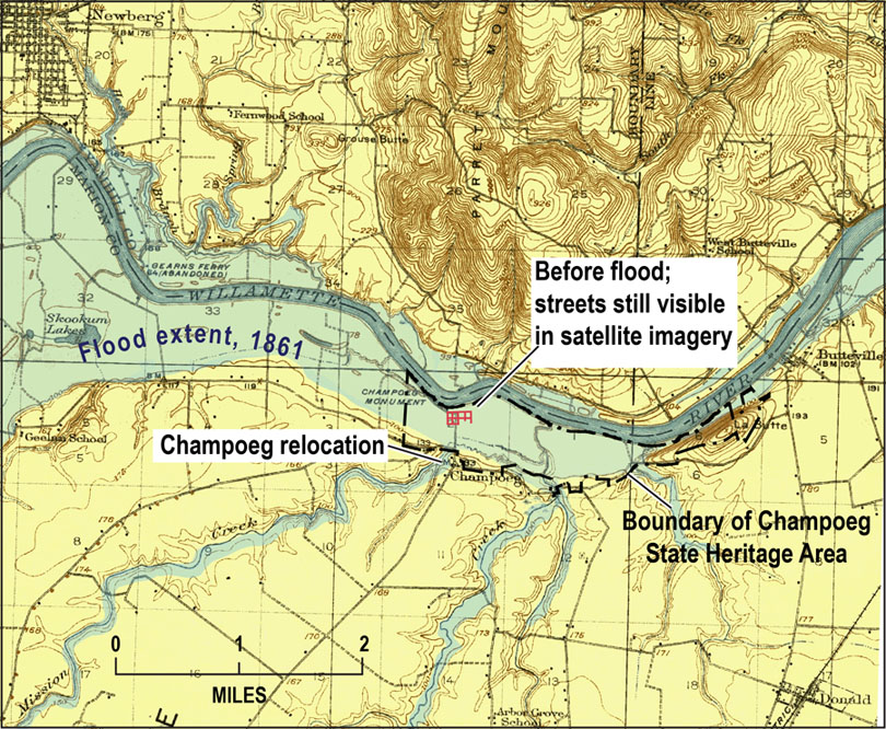
In December 1861, a warm Chinook wind melted snow in the Cascade Mountains and, combined with continual rain, caused the Willamette River to flood. The flooding reached its height on December 5 and 6, covering Champoeg with about 30 feet of fast-moving water and sweeping away all of the town’s structures except the Hudson’s Bay Company warehouse. While there was no loss of life at Champoeg, the community vanished. After the flood, “one saw only drifting sand, and land denuded of its soil marked the abandoned townsite,” according to a recollection by Samuel Asahel Clarke. The flood of March 1890, which very nearly equaled that of 1861, again scoured the townsite.
Champoeg was not rebuilt. The post office and a few businesses moved south onto the benchland near the Robert Newell house and the present intersection of Champoeg Road and French Prairie Road. In 1864, the Champoeg post office was renamed Newellsville, in honor of Robert Newell, although he had left the area for Idaho and died there in 1869. The name was changed back to Champoeg in 1880, and the post office was closed in 1905. The flour mill had survived the flood, and a few warehouses were erected to serve river traffic.
Champoeg’s position as a land and river crossroads greatly diminished after 1871 with the construction of railroads down the valley. When representatives of the Oregon Historical Society attempted in 1900 to locate the site of the historic May 2, 1843, Provisional Government meeting, the absence of landmarks made it a difficult effort.
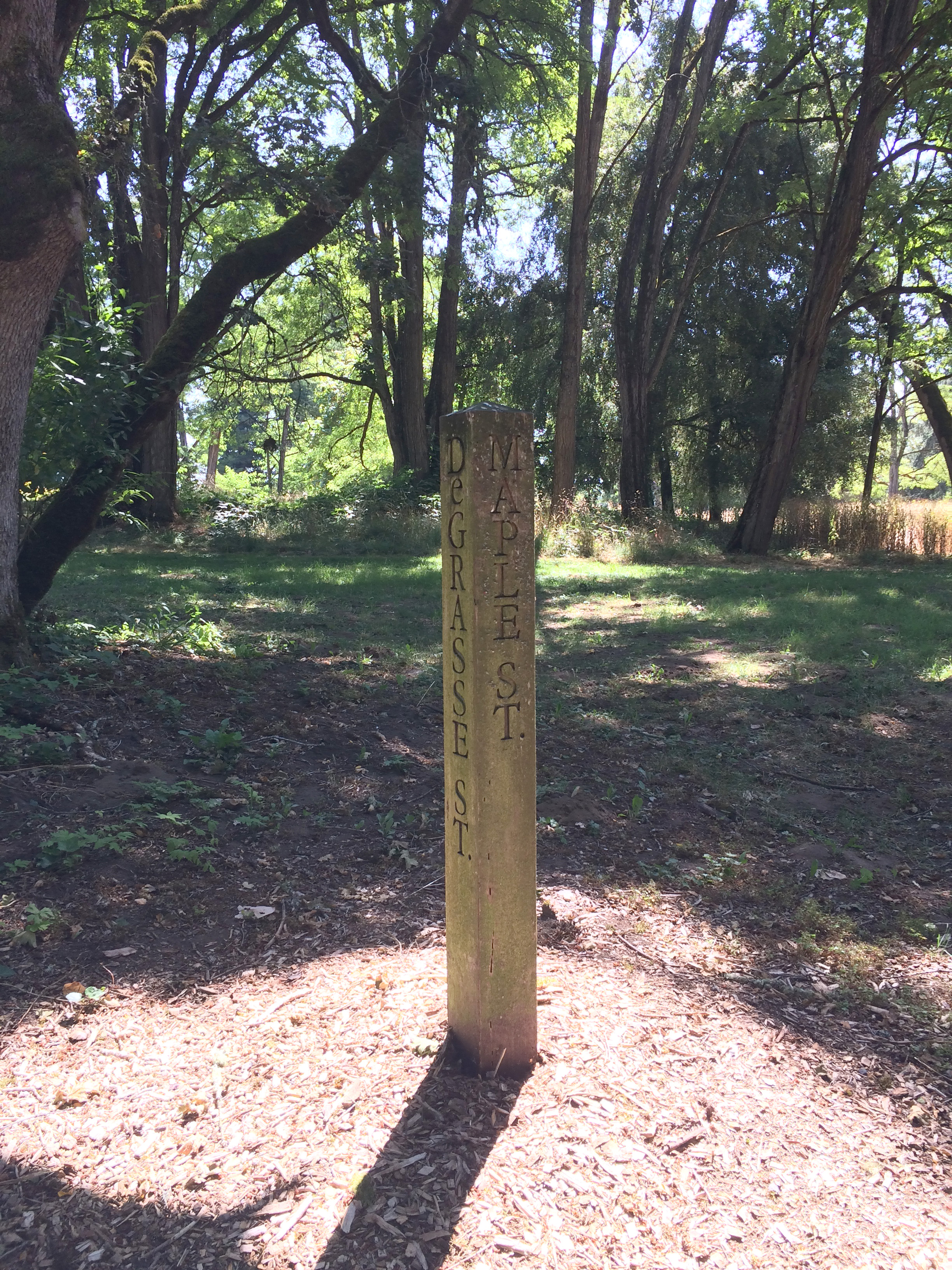
The townsite is faintly visible at the Champoeg State Heritage Area, with the location of former streets—Jefferson, Napoleon, Washington, and Montcalm among them—marked by posts on the French Prairie landscape.
-
![]()
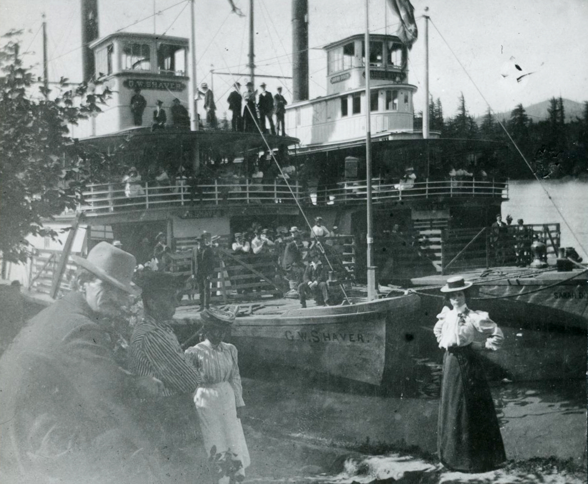
Summertime crowd on the sternwheelers G.W. Shaver and Sarah Dixon, Champoeg, c.1890.
Courtesy Oregon Hist. Soc. Research Lib., 002925
-
![]()
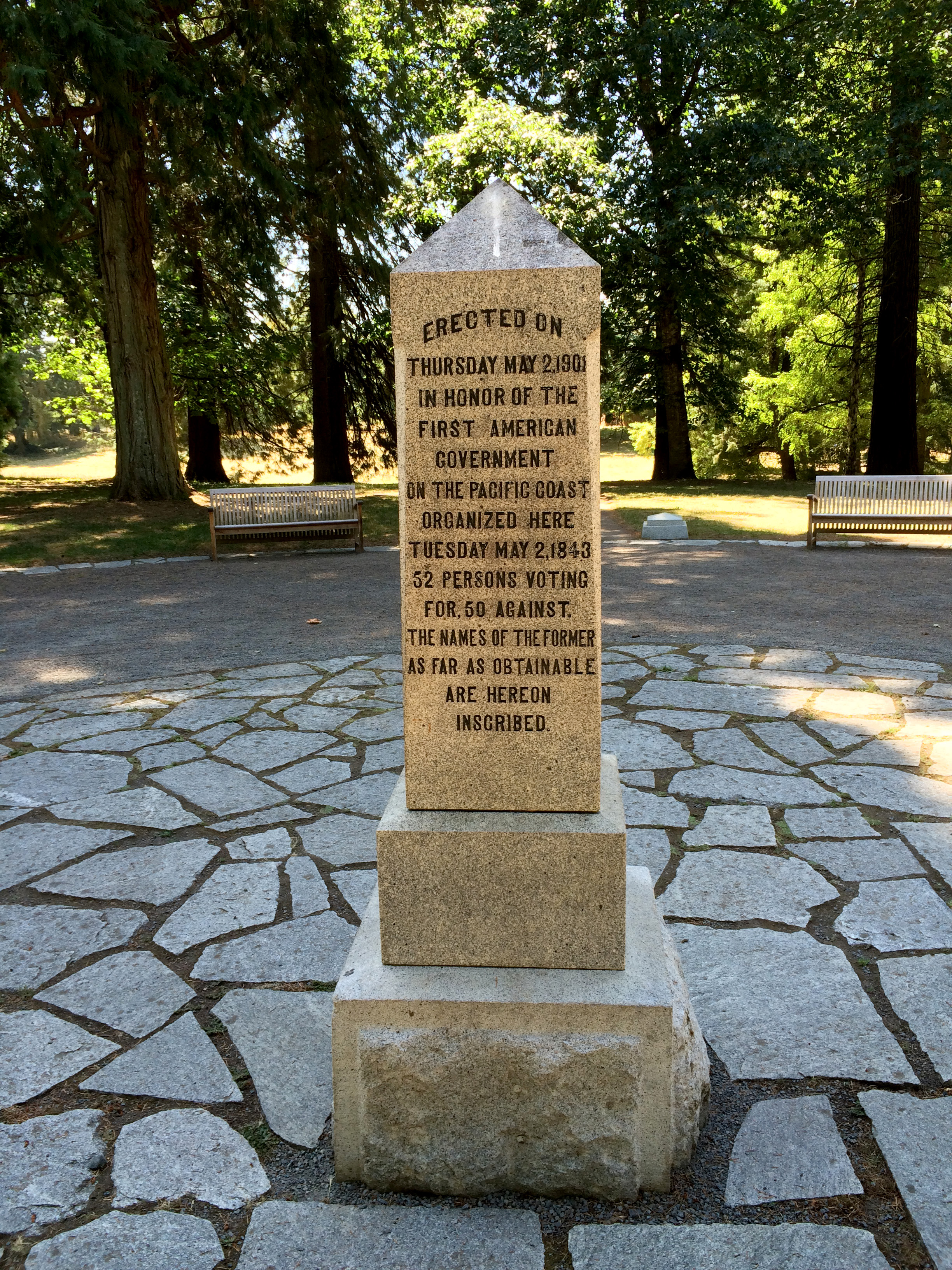
Provisional Government Memorial, Champoeg State Heritage Area, 2016.
Courtesy A.E. Platt
-
![]()
"Joe Meek Appeals for the American Flag, at Champoeg, May 2, 1843." Illustration by Caughey..
Courtesy Willamette Heritage Center Collections, 2004.010.0824
-
![]()
Base Topographic map of the 1861 Willamette River flood..
Courtesy David Sherrod
-
![]()
Champoeg Landing, 1908.
Courtesy Oregon Hist. Soc. Research Lib., Orhi35288
-
![]()
Sign marking the former Maple and Degrasse Streets in Champoeg, Oregon, 2016.
Courtesy A.E. Platt
-
![Hudson's Bay Warehouse at far right]()
Drawing of Champoeg Village, by ethnologist George Gibbs, 1851.
Hudson's Bay Warehouse at far right Courtesy Oregon Hist. Soc. Research Lib., 002924
-
![]()
Pencil sketch of Champoeg by ethnologist George Gibbs, 1851.
Courtesy Oregon Hist. Soc. Research Lib., Peabody Museum, 008334
-
![]()
Champoeg schoolhouse, c.1850s.
Courtesy Oregon Hist. Soc. Research Lib., John Atherton report, 1974, 979.134a869
-
![From Historical Atlas Map of Marion County]()
Sketch of Hurst and Brothers Grist Mill, Champoeg Creek, Market Road 12.
From Historical Atlas Map of Marion County Courtesy Oregon Hist. Soc. Research Lib., bc005792 44494, photo file 228
-
![]()
Champoeg Landing, 1890.
Courtesy Oregon Hist. Soc. Research Lib., Orhi8379
-
![]()
Looking across the river at Champoeg Landing, steamers Pomona and Bonita at landing, c.1895.
Courtesy Oregon Hist. Soc. Research Lib., Burelbach, 015754
-
![]()
Case Schoolhouse, built in 1852, near Champoeg, c.1900.
Courtesy Oregon Hist. Soc. Research Lib., 021161
-
![]()
Henry Zorn house, near Champoeg, 1939.
Courtesy Oregon Hist. Soc. Research Lib., Verne Bright, photo file 228
-
![]()
Gov. T.T. Geer, George Himes, and François X. Matthieu at site of Champoeg, c.1900.
Courtesy Oregon Hist. Soc. Research Lib.,Orhi4251
-
![]()
Champoeg Landing, 1907.
Courtesy Oregon Hist. Soc. Research Lib., bc005202, photo file 228
-
![The steamship Pomona (r) at Champoeg landing, 1908.]()
Champoeg Landing, 1908, OrHi 35288.
The steamship Pomona (r) at Champoeg landing, 1908. Oreg. Hist. Soc. Research Libr., OrHi 35288
-
![]()
Steamboats at Champoeg Landing.
Courtesy Oregon Hist. Soc. Research Lib., photo file 228
-
![]()
Champoeg Mill and covered bridge across Champoeg Creek, 1939.
Courtesy Oregon Hist. Soc. Research Lib., Fed. Works Progress, Verne Bright, Orhi83085, photo file 228
-
![]()
"Ghost stores" at the relocated Champoeg, named Newellsville, 1939.
Courtesy Oregon Hist. Soc. Research Lib., bc005186, photo file 228
-
![]()
Monument to first provisional government, Champoeg, c.1910.
Courtesy Oregon Hist. Soc. Research Lib., 003000
-
![]()
American flag covers the monument to the first provisional government in Oregon, dedication 1901.
Courtesy Oregon Hist. Soc. Research Lib., 015756, Burelbach
-
![]()
Benches fill covered area at Champoeg Pioneer Memorial Building, c. 1920.
Courtesy Oregon Hist. Soc. Research Lib., Burelbach, 015753
-
![]()
Pioneer Memorial Building, Champoeg, c.1918.
Courtesy Oregon Hist. Soc. Research Lib., 003005
-
![]()
Champoeg Pioneer Monument and Building, 2016.
Courtesy A.E. Platt
-
![]()
Champoeg Pioneer Memorial Building, 2016.
Courtesy A.E. Platt
-
![]()
High water mark for the 1861 flood on the Pioneer Memorial Building, 2016.
Courtesy A.E. Platt
-
![The cabin was moved to the Newell Pioneer Village in 2013.]()
Pioneer Mothers Memorial Cabin, on Champoeg Rd., 2016.
The cabin was moved to the Newell Pioneer Village in 2013. Courtesy A.E. Platt
-
![Image of the dedication, 1901]()
The Statesman Journal's feature on Champoeg, March 4, 1999.
Image of the dedication, 1901 Courtesy Oregon Hist. Soc. Research Lib., vertical file, Champoeg


Related Entries
-
![French Prairie]()
French Prairie
Located in Oregon's mid-Willamette Valley, French Prairie was resettled…
-
![Hudson's Bay Company]()
Hudson's Bay Company
Although a late arrival to the Oregon Country fur trade, for nearly two…
-
![Joseph Gervais (1777-1861)]()
Joseph Gervais (1777-1861)
Joseph Gervais was a prominent French Canadian settler in the Willamett…
-
![Kalapuyan peoples]()
Kalapuyan peoples
The name Kalapuya (kǎlə poo´ yu), also appearing in the modern geograph…
-
![Provisional Government]()
Provisional Government
The Provisional Government, created in May-July 1843, was the first gov…
-
![Robert Newell (1807–1869)]()
Robert Newell (1807–1869)
In 1840, after more than a decade in the Rocky Mountain fur trade, Robe…
Related Historical Records
Map This on the Oregon History WayFinder
The Oregon History Wayfinder is an interactive map that identifies significant places, people, and events in Oregon history.
Further Reading
Corning, Howard McKinley. Willamette Landings: Ghost Towns of the River. Third Edition. Portland: Oregon Historical Society, 2004.
Hussey, John A. Champoeg: Place of Transition: a Disputed History. Portland: Oregon Historical Society, 1967.
S. A. C. [Samuel Asahel Clarke]. “The Great Flood.” Oregonian, February 21, 1888, page 8