Approximately three thousand ships have met their fate in Oregon waters. Many wrecks occurred at river bars where strong currents carrying sand and other deposits cause the river bottom to continually change. The flow of fresh water from rivers into the Pacific Ocean can cause intense and unpredictable sea conditions. Strong ebb currents pushing against the opposing forces of the ocean can build enormous swells in a very short time, threatening to overcome unprepared ships crossing the river bars. Other causes of shipwrecks include mechanical failure and rough coastal weather on unforgiving rocky shores. The causes of some early shipwrecks remain unknown, including that of a Spanish Galleon which spilled its cargo along the Nehalem Spit, c. 1693-1705.
The Columbia River Bar
The majority of Oregon shipwrecks have occurred on or near the Columbia River bar, where the ebb tides of the Columbia run into the flood tides of the Pacific. Strong currents, a shallow channel, and powerful winds—which can capsize poorly loaded ships and create foggy conditions—have made the bar one of the most deadly in the world. Its nickname is the Graveyard of the Pacific.
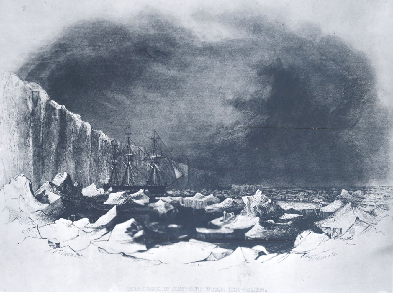
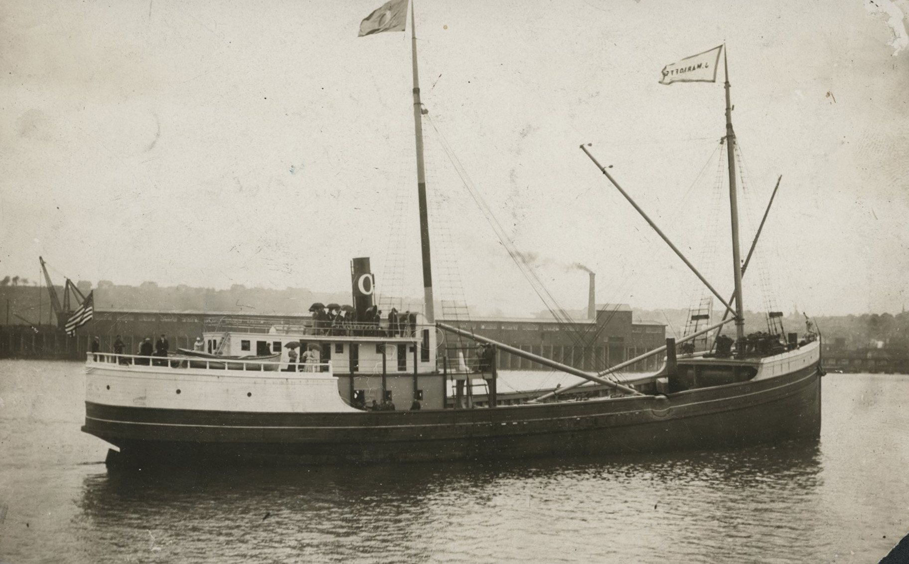
The U.S.S. Peacock, a naval sloop of war, grounded on the north shore in 1841 near Cape Disappointment, where heavy seas broke up the ship. The crew escaped by boat with no casualties, and the area where the ship wrecked is now called Peacock Spit. Five years later, another naval ship, the schooner U.S.S. Shark, grounded on the southern bank of the Columbia River bar. Tremendous seas broke the ship into pieces, and some of its carronades drifted south along the coast. One came ashore in the area now called Cannon Beach. Two additional carronades from the U.S.S. Shark were discovered at Arch Cape in 2008.
The American steamer Great Republic, the largest passenger ship on the Pacific Coast at the time, turned late and grounded near Sand Island at the mouth of the Columbia in April 1879. Despite many attempts to refloat the ship, it was broken up by heavy seas and abandoned. The passengers and much of the cargo were saved, but eleven members of the crew were drowned when the last lifeboat sank.
Before the availability of radar and Global Positioning Systems, mariners’ eyes and ears were the principal tools for detecting hazards on the Oregon Coast when approaching from the sea. Coastal weather is often foggy and misty, and ships sometimes discovered the rocky shore too late to avoid disaster. The morning mist along Clatsop Spit, for example, confused the captain of Peter Iredale, which found itself in the breakers in October 1906. The currents and tides held the ship on the beach, and the crew was rescued by breeches buoy, which uses a life ring with attached canvass breeches to allow survivors to slide down a rope between the ship and shore. The ship was a total loss, and the remaining hull is a tourist attraction at Fort Stevens State Park.
The freighter Mauna Ala was on its way to Hawaii with its holds full of Christmas trees and holiday items when the captain was ordered back to Astoria after the Japanese attack on Pearl Harbor on December 7, 1941. On December 10, the darkened wartime coast was unfamiliar to the captain, and the freighter ran aground on Clatsop Spit, just south of the old Peter Iredale wreck. All hands were saved, but the wreck remains buried on the beach or under the surf.
Other Oregon Bars
In 1808, the British fur trading vessel Sea Otter ran into stormy weather and wrecked at the mouth of the Umpqua River near Reedsport. The six survivors had to walk across half the continent to Louisiana to arrange transportation back to England.
The U.S. Navy’s minesweeper YMS-133 learned the lesson of treacherous swells where the river meets the sea. When the ship attempted to cross the Coos Bay bar in February 1943, the captain tried to come about in the channel when the minesweeper was rolled over on her beam and smashed into the sandbar. Thirteen of her complement of twenty-nine were lost.
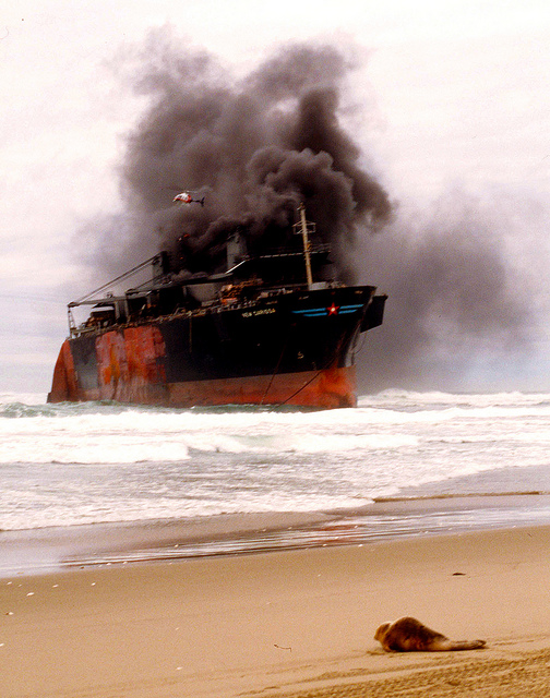
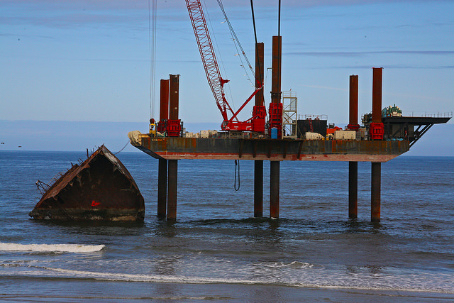
The freighter, New Carissa, grounded on the North Spit near North Bend, on February 4, 1999. High winds and twenty-six-foot swells drove the ship onto Horsefall Beach, leading to one of Oregon's worst oil spills.
Mechanical Failures
Problems inside a ship have led to disaster. On May 18, 1910, for example, the captain and crew of the steamer J. Marhoffer were enjoying a calm afternoon on the passage from San Francisco to Portland when a gas torch exploded, setting fire to the engine room. The captain steered toward the rocky shore as fire engulfed the ship, and the steamer went onto the rocks just north of Depoe Bay. The crew escaped in small boats. The rusted boiler is all that remians of the wreckage, at what is now known as Boiler Bay,
The steamer Argo was on the final leg of its voyage from Portland to Garibaldi on November 26, 1909. The ship’s port screw snapped off and forced it onto a sandbar at the entrance to Tillamook Bay. The Garibaldi Lifesaving Station dispatched rescue boats, while some of the crew and passengers took to the ship’s boats. The raging sea took the lives of several passengers, crew, and lifesavers as rescue boats capsized in the rough surf.
The Russian freighter Vazlav Vorovsky lost steering control and grounded on the north side of the Columbia River, approximately a half mile south of the Cape Disappointment lighthouse, on April 3, 1941. Despite the efforts of the captain to free the ship from the shoreline, the Vazlav Vorovsky broke up and disappeared. No lives were lost thanks to quick efforts by the Coast Guard.
Foggy Shores
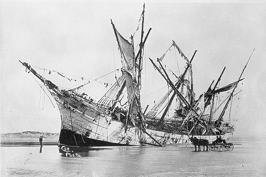
The British bark Carinsmore became lost in the fog off Clatsop Spit in September 1883. The ship drifted into the surf and grounded on what is now Fort Stevens State Park, and the steamer Queen of the Pacific rescued the Cairnsmore’s crew. The remains of the bark were visible for many years.
The American bark Emily Reed crashed into the fog-shrouded sand near Rockaway Beach on February 14, 1908. Eight of the seventeen crew and passengers died. The wreck is buried beneath the sand, but storms occasionally uncover the well-worn wooden beams.
The captain of the German square-rigger Mimi mistook the entrance to the Nehalem River for the Columbia Bar. In thick weather in February 13, 1913, the ship ran hard onto the Nehalem Spit. Up to eighteen men drowned when the ship capsized during an ill-fated salvage attempt in April.
Improved Safety
Efforts to reduce the number of shipwrecks on the Oregon Coast include documenting hazards and changing the environment. The U.S. Navy and the U. S. Coast Survey documented the treacherous shores and bars of the coast on nautical charts, and the U.S. Lighthouse Service and the U.S. Coast Guard developed lighthouses and buoy systems that mark rocky coasts and shoalwater. Stone jetties on the south and north ends of the Columbia River Bar were constructed by the U.S. Army Corps of Engineers between the 1885 and 1917, and the Corps maintains the depth of the water by dredging. Jetties were also built at Garibaldi and other dangerous river entrances to stabilize water depth and sand movement. Jetties decreased the number of ships wrecked while crossing the bar, but with rough weather and rocky coastline Oregon remains a dangerous place for ships.
-
![]()
The wreck of the Cairnsmore, 1882.
Courtesy Oregon Hist. Soc. Research Lib., 36619, ba006338, photo file 2146
-
![]()
New Carissa Shipwreck, February 1999.
Courtesy Bureau of Land Management Oregon and Washington
-
![]()
The wreck of the Peter Iredale, 1906.
Courtesy Oregon Hist. Soc. Research Lib., OrHi 12297
-
!["Peacock contact with iceberg with Wilkes Expedition." Drawing by M. Osbourne.]()
U.S.S. Peacock.
"Peacock contact with iceberg with Wilkes Expedition." Drawing by M. Osbourne. Courtesy Oreg. Hist. Soc. Research Library, OrHi91013
-
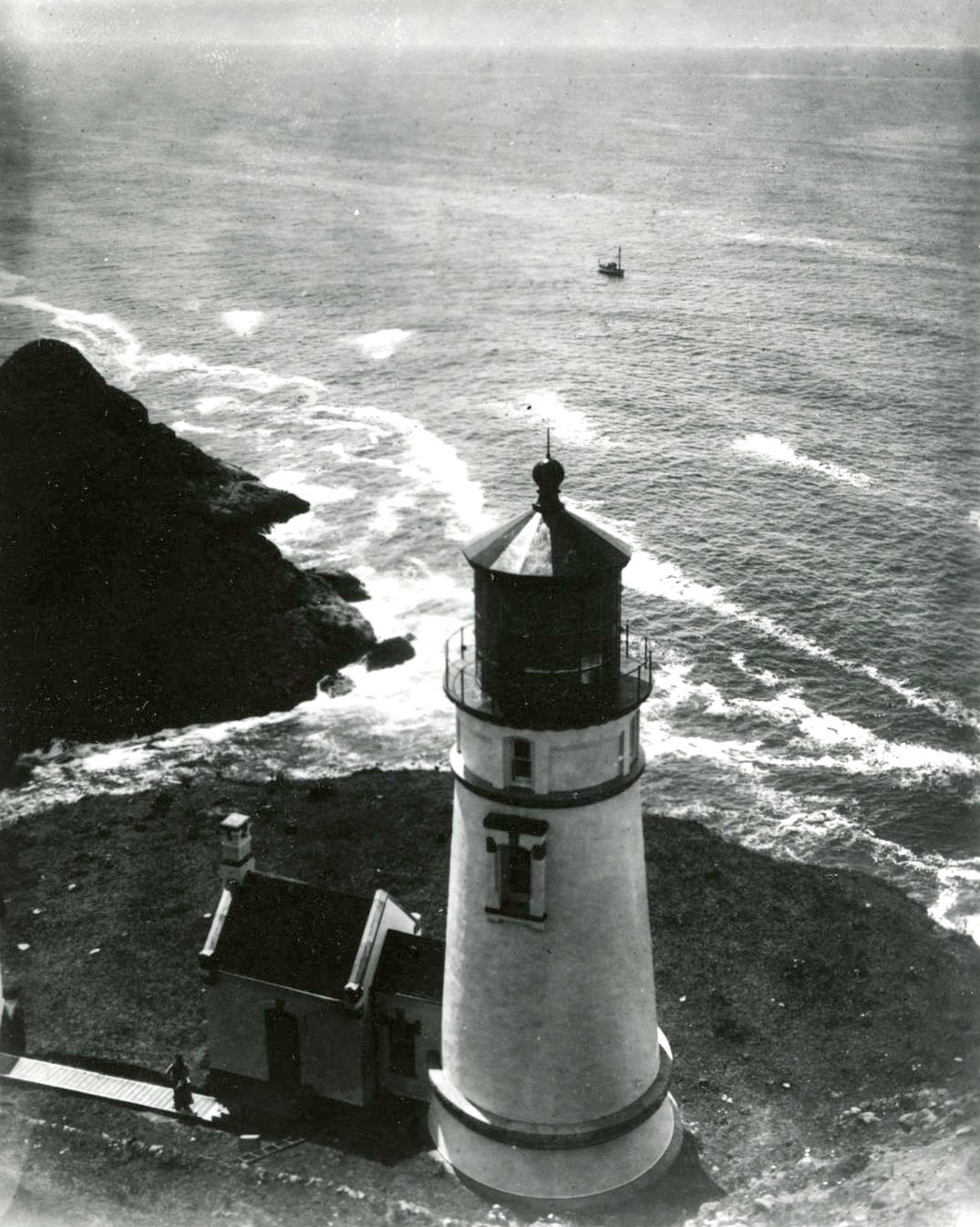
![]()
Heceta Head Lighthouse, 1931. Keeper waves from the walkway..
Courtesy Oregon Hist. Soc. Research Lib., Journal Coll., 013305
-
![]()
The Shark on a Mediterranean Cruise, 1935-8; watercolor by Francois Roux.
Courtesy Oregon Hist. Soc. Research Lib., 13289, photo file 1164
-
![]()
The Great Republic in lower Portland Harbor, 1878.
Courtesy Oregon Hist. Soc. Research Lib., bc001882, 141, photo file 2533
-
![]()
The Great Republic in San Francisco Harbor.
Courtesy Oregon Hist. Soc. Research Lib., Frank Abell, photographer, Orhi141, bc001879, photo file 2533
-
![]()
Great Republic.
Courtesy Oregon Hist. Soc. Research Lib., bc001828, photo file 2533
-
![]()
Wreck of the Great Republic on Sand Island, Columbia River, 1879.
Courtesy Oregon Hist. Soc. Research Lib., bc001880, 59373, photo file 2533
-
![]()
S.S. Mauna Ala, December 1941.
Courtesy Oregon Hist. Soc. Research Lib., bc001485, photo file 2540
-
![]()
The Mauna Ala after running aground on the Clatsop Spit, December 10, 1941.
Courtesy Oregon Hist. Soc. Research Lib., bc001490, photo file 2540
-
![]()
Mauna Ala, outbound for Honolulu, went ashore in a blackout at the mouth of the Columbia, December 11, 1941.
Courtesy Oregon Hist. Soc. Research Lib., bc59364, bc001486, photo file 2540
-
![]()
The Mauna Ala stranded on Clatsop Beach, December 1941.
Courtesy Oregon Hist. Soc. Research Lib., photo file 2540
-
![]()
Flotsam from the Mauna Ala, December 1941.
Courtesy Oregon Hist. Soc. Research Lib., bc001484
-
![]()
Remains of New Carissa Shipwreck, 2008.
Courtesy Bureau of Land Management Oregon and Washington
-
![]()
The J. Marhoffer.
Courtesy Oregon Hist. Soc. Research Lib., bc001670
-
![]()
Vazlav Vorovsky, Cape Disappointment, 1941.
Courtesy Oregon Hist. Soc. Research Lib., Journal, photo file 2511
-
![]()
Vazlav Vorovsky, October 1941.
Courtesy Oregon Hist. Soc. Research Lib., Journal, bc002413, photo file 2511
-
![]()
Vazlav Vorovsky.
Courtesy Oregon Hist. Soc. Research Lib., bc002415, photo file 1192
-
![]()
"Mimi by Moonlight" on Nehalem Beach.
Courtesy Oregon Hist. Soc. Research Lib., Orhi57983, ba006684, photo file 1168
-
![]()
The Mimi on Neahkanie Beach, 1913.
Courtesy Oregon Hist. Soc. Research Lib., 45051, ba006680, photo file 1169a
-
![]()
Aerial of the Columbia River bar, 1930.
Courtesy Oregon Hist. Soc. Research Lib., Brubaker Aerials, 11711, photo file 267
-
![]()
Columbia River jetty after a storm, 1909.
Courtesy Oregon Hist. Soc. Research Lib., photo file 267
-
![]()
Jetty at the mouth of the Columbia River.
Courtesy Oregon Hist. Soc. Research Lib., photo file 267
-
![]()
One of the rocks used to build the jetties at the mouth of the Columbia River, 1908.
Courtesy Oregon Hist. Soc. Research Lib., Orhi103032, photo file 267
-
![]()
Piledriver on the end of the jetty at the mouth of the Columbia River, c.1910.
Courtesy Oregon Hist. Soc. Research Lib., 68159, photo file 267
-
![]()
Jetty at the mouth of the Columbia River.
Courtesy Oregon Hist. Soc. Research Lib., Spokane, Portland, & Seattle Railway coll., 68158, photo file 267
-
![]()
Jetty at the mouth of the Columbia River, 1910.
Courtesy Oregon Hist. Soc. Research Lib., photo file 267
-
![]()
Barview Coast Guard Station.
Courtesy Oreg. Hist. Soc. Research Lib., neg. no. 007043
-
![]()
Point Adams Coast Guard station, Hammond, 1957.
Courtesy Oregon Hist. Soc. Research Lib., 006099


Related Entries
-
![Beeswax shipwreck]()
Beeswax shipwreck
Since the earliest days of EuroAmerican settlement on the Oregon Coast,…
-
![Columbia River]()
Columbia River
The River For more than ten millennia, the Columbia River has been the…
-
![Columbia River Bar Pilots]()
Columbia River Bar Pilots
The extensive, dangerous bar channel at the entrance to the Columbia Ri…
-
![Fort Stevens]()
Fort Stevens
One of the three major forts designed to protect the mouth of the Colum…
-
![Konapee wreck]()
Konapee wreck
The possible wreck of a European ship at Point Adams, on the southern e…
-
![New Carissa]()
New Carissa
The New Carissa, a 639-foot freighter, wrecked on the North Spit near N…
-
![Santo Cristo de Burgos]()
Santo Cristo de Burgos
The Manila Galleon Trade and the Wreck on the Oregon Coast Nehalem-Til…
-
![The Wreck of the Congress (ship)]()
The Wreck of the Congress (ship)
The rescue of all 445 people aboard the burning passenger steamer Congr…
-
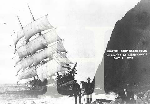
![The Wreck of the Glenesslin (ship)]()
The Wreck of the Glenesslin (ship)
The 1913 wreck of the Glenesslin is one of Oregon’s most enigmatic and …
-
![U.S.S. Peacock]()
U.S.S. Peacock
The U.S.S. Peacock, a ten-gun, three-masted sloop, was the first ship o…
-
![Wreck of the General Warren (ship)]()
Wreck of the General Warren (ship)
The highly publicized wreck of the General Warren in January 1852 off t…


Related Historical Records
Map This on the Oregon History WayFinder
The Oregon History Wayfinder is an interactive map that identifies significant places, people, and events in Oregon history.
Further Reading
Gibbs, James A. Shipwrecks of the Pacific Coast, Second Edition. Portland, Ore.: Binfords and Mort, , 1962
Griffin, Dennis. "A History of Underwater Archaeological Research in Oregon." The Journal of Northwest Anthropology (2013).
Haglund, Michael E. Worlds Most Dangerous: A History of the Columbia River Bar its Pilots and their Equipment. Astoria, Ore.: Columbia River Maritime Museum, 2011.
Hickson, R. E., and F. W. Rodolf. "History of the Columbia River Jetties." Proceedings of First Conference on Coastal Engineering, Long Beach, California, October, 1950. Coastal Engineering Research Council of the COPRI (Coasts, Oceans, Ports, Rivers Institute) of the American Society of Civil Engineers.
Marshall, Don. Oregon Shipwrecks. Portland, Ore.: Binfords and Mort, 1984.