The Santiam Wagon Road was a vital commercial link connecting the Willamette Valley with central Oregon. Built between 1861 and 1868, the road, which closely followed traditional Indian trails, was in use into the late 1930s and made possible the settlement of central Oregon.
In 1846, the opening of the Barlow Road and the Applegate Trail stimulated interest in finding more central routes for settlers to reach the Willamette Valley. The Oregon Provisional Government authorized Hudson’s Bay Company trapper Thomas McKay to open a road from Albany to the Malheur River by August 1, 1846. He followed the South Santiam River but was unable to find a suitable wagon route.
By the late 1850s, most of the good farm and ranch land in the mid-Willamette Valley had been taken, and even those settlers who had good land wanted additional grassland range for their horses and cattle. The only road in the area was a county road from Albany through Lebanon and Sweet Home and across a bridge at Wiley Creek, east of Sweet Home. Settlers wanted a route that connected Albany with the bunchgrass range in central Oregon.
In September 1859, Andrew Wiley, John Gray, John Brandenburg, and Harvey Wiley attempted to find the Santiam Pass beginning at Wiley Creek. After twenty days they reached the Deschutes River, thereby connecting the Indian trails and the McKay route. Gray wrote of this route that “a good cattle trail could be opened” as well as a wagon road, which “could be made as good and as cheap as either of the Mt. Hood roads.” Andrew Wiley was confident that a good road could be constructed inexpensively from his residence near the South Santiam River and over the Cascade Mountains, connecting with the 1845 Meek Cutoff of the Oregon Trail, which led to Fort Boise on the Snake River.
Construction of a county road that was later incorporated into the Santiam Wagon Road began in 1861. Luther Elkins, D.W. Balland, Morgan Kees, John Settle, Isaac Coryell (later replaced by Jeremiah Ralston), Jacob Kees, and James H. Richardson incorporated the Willamette Valley and Cascade Mountain Wagon Road Company on March 10, 1864. The road was to begin on the east side of the Willamette River opposite Corvallis, although the starting point was later changed to Albany.
An 1866 state charter allowed the company to charge a toll. Oregon officials also granted the company title to 800,000 acres between Albany and Ontario. By 1867, the road was completed to Fish Lake in Linn County and in 1868 to the Deschutes River. In 1887, the company spent $86,805.75 improving the road using Chinese laborers. Jason Wheeler oversaw the construction until August 1865; afterward, he served as assistant to J.A. White.
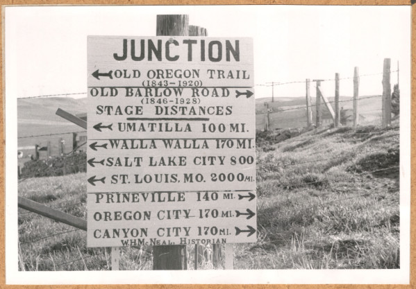
In 1868, the first tollgate on the road was established on John Gilliland’s claim east of Sweet Home, with Gilliland the gatekeeper and road superintendent. The eastern tollgate was at Cache Creek in Deschutes County. In 1880, John McKee became the western gatekeeper and moved the tollgate to a mile west of Lower Soda Falls; Jacob Nye replaced McKee in 1891.
The 1870s through the 1880s was a period of heavy traffic along the Santiam Wagon Road, with hundreds of four- and six-horse teams pulling wagon trains—some a half-mile long—loaded with wool from eastern Oregon headed to mills at Brownsville and Waterloo. The wagons returned with fruit, vegetables, and other supplies. Thousands of cattle were also driven over the road to grazing pastures.
Frank Rumbaugh became the road superintendent in 1893. He was replaced in the spring of 1897 by A.J. McClure, who had to make several bridge repairs. In 1898, George Geisendorfer established a post office at Cascadia in Linn County and built a bridge across the South Santiam River west of the tollgate. Because people were going around the gate to avoid paying the toll, the gate was returned to Lower Soda Falls and later Canyon Creek. M.J. Nye, Jake Nye’s son, became the gatekeeper in 1908; he continued in that position until 1914, when tolls were discontinued. The toll was resumed for 1921 to pay for needed road repairs.
Campgrounds and roadhouses were established along the route for rest and replenishment. For several years, Joe Claypool operated the Willamette Valley and Ochoco Stage Line along the Santiam Wagon Road for both passengers and mail. In 1905, the first United States transcontinental automobile race followed the Santiam Wagon Road. Leading driver Dwight Huss paid a three-cent toll to pass as a “road hog” for his seven horsepower 1904 Oldsmobile Runabout.
Completed in September 1939, U.S. Highway 20 (called the Santiam Highway) closely follows the Santiam Wagon Road. In September 2010, the road was listed on the National Register of Historic Places.
-
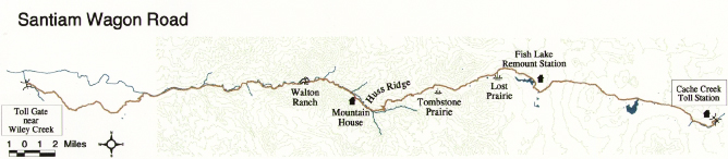
![Map of Santiam Wagon Road.]()
Santiam Wagon Road map, USFS.
Map of Santiam Wagon Road. U.S. Forest Service
Related Entries


Map This on the Oregon History WayFinder
The Oregon History Wayfinder is an interactive map that identifies significant places, people, and events in Oregon history.
Further Reading
Santiam Wagon Road National Register of Historic Places Registration Form. Listed Sep. 23, 2010.